
Carte topographique Bù Đăng District
Carte interactive
Cliquez sur la carte pour afficher l’altitude.
À propos de cette carte
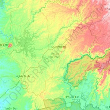
Nom : Carte topographique Bù Đăng District, altitude, relief.
Lieu : Bù Đăng District, Bình Phước Province, Vietnam (11.50153 107.04744 12.03909 107.42765)
Altitude moyenne : 287 m
Altitude minimum : 81 m
Altitude maximum : 749 m
Autres cartes topographiques
Cliquez sur une carte pour visualiser sa topographie, son altitude et son relief.
Phường Long Phước
Vietnam > Bình Phước Province > Phước Long Town
Phường Long Phước, Phước Long Town, Bình Phước Province, Vietnam
Altitude moyenne : 209 m
Bình Long Town
Bình Long Town, Bình Phước Province, Vietnam
Altitude moyenne : 91 m
Hưng Long
Vietnam > Bình Phước Province > Chơn Thành Town
Hưng Long, Chơn Thành Town, Bình Phước Province, Vietnam
Altitude moyenne : 62 m
Xã Phước Tín
Vietnam > Bình Phước Province > Phước Long
Xã Phước Tín, Phước Long, Bình Phước Province, Vietnam
Altitude moyenne : 214 m
Nghĩa Bình
Vietnam > Bình Phước Province > Bù Đăng District
Nghĩa Bình, Bù Đăng District, Bình Phước Province, Vietnam
Altitude moyenne : 231 m
Phước Long
Vietnam > Bình Phước Province > Phước Long
Phước Long, Bình Phước Province, Vietnam
Altitude moyenne : 202 m