
Carte topographique Garissa
Carte interactive
Cliquez sur la carte pour afficher l’altitude.
Garissa
Garissa has a hot arid climate (Köppen climate classification BWh), despite receiving around 375 millimetres or 15 inches of rainfall per year, due to the extremely high potential evapotranspiration. Garissa's landscape is mostly arid, desert terrain. The city lies along the Tana River, and has a hot climate due to the low elevation and distance from cooler coastal areas. The daytime temperature typically rises above 33 °C or 91.4 °F every day, but cools down every night.
À propos de cette carte
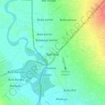
Nom : Carte topographique Garissa, altitude, relief.
Lieu : Garissa, Garissa Township, Garissa, North Eastern, Kenya (-0.49065 39.63397 -0.42066 39.67719)
Altitude moyenne : 149 m
Altitude minimum : 133 m
Altitude maximum : 195 m
Autres cartes topographiques
Cliquez sur une carte pour visualiser sa topographie, son altitude et son relief.