
Faire un don
Équipez-vous pour votre prochaine aventure :
En tant que Partenaire Amazon, ce site perçoit une commission sur les achats éligibles sans surcoût pour vous.
Carte topographique Te Mata Peak
Cliquez sur la carte pour afficher l’altitude.
Faire un don
Équipez-vous pour votre prochaine aventure :
En tant que Partenaire Amazon, ce site perçoit une commission sur les achats éligibles sans surcoût pour vous.
Te Mata Peak
Te Mata Peak is a peak south of Hastings rising up to 399m in the Te Mata Hills in the Hawke's Bay region of New Zealand. A sealed road leads to the popular lookout at the summit, as well as many trails for hikers and mountain bikers. The Hastings suburb of Havelock North is situated at the base of the peak. Te Mata peak and the surrounding range runs in a North-East to South-West direction. The slopes on the North-Western side build up gradually. Havelock North is built upon the rolling hills at the lower extent of the ranges. The topography of the South-Eastern side has been heavily influenced by the Tukituki River, forming the Tukituki Valley. From Te Mata Peak, cliffs on the South-Eastern side drop 140 meters before extending into the rolling hills of the Tukituki Valley, making these cliffs some of the highest in the North Island of New Zealand. Their height is subject to erosion, with multiple instances of rockfall into the valley below. From the peak, large boulders can be witnessed in the valley as evidence of previous rockfall.
Faire un don
Équipez-vous pour votre prochaine aventure :
En tant que Partenaire Amazon, ce site perçoit une commission sur les achats éligibles sans surcoût pour vous.
À propos de cette carte
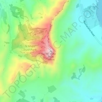
Nom : Carte topographique Te Mata Peak, altitude, relief.
Altitude moyenne : 144 m
Altitude minimum : 19 m
Altitude maximum : 391 m
Faire un don
Équipez-vous pour votre prochaine aventure :
En tant que Partenaire Amazon, ce site perçoit une commission sur les achats éligibles sans surcoût pour vous.