
Carte topographique Ios
Carte interactive
Cliquez sur la carte pour afficher l’altitude.
À propos de cette carte
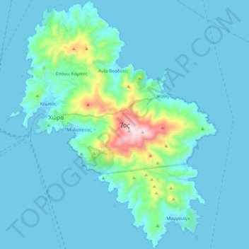
Nom : Carte topographique Ios, altitude, relief.
Lieu : Ios, Thira Regional Unit, South Aegean, Aegean, 840 01, Greece (36.64210 25.24594 36.79256 25.40308)
Altitude moyenne : 73 m
Altitude minimum : 0 m
Altitude maximum : 717 m
The highest elevation (723 m, 2372 ft) is the Kastro (Greek: Κάστρο) peak also called Pyrgos (Greek: Πύργος), located in the center of the island, while around the Kastro are the next three Highest peaks: Xylodema (Greek: Ξυλόδεμα) (660 m, 2165 ft), Kostiza (Greek: Κοστίζα) (586 m, 1923 ft) and Prophetis Elias (Greek: Προφήτης Ηλίας) (490 m, 951 ft).
Autres cartes topographiques
Cliquez sur une carte pour visualiser sa topographie, son altitude et son relief.
Santorini
Greece > Aegean > Thira Regional Unit > Thira Municipal Unit
Santorini, Thira Municipal Unit, Municipality of Thira, Thira Regional Unit, South Aegean, Aegean, Greece
Altitude moyenne : 30 m