
Faire un don
Équipez-vous pour votre prochaine aventure :
En tant que Partenaire Amazon, ce site perçoit une commission sur les achats éligibles sans surcoût pour vous.
Carte topographique Franca
Cliquez sur la carte pour afficher l’altitude.
Faire un don
Équipez-vous pour votre prochaine aventure :
En tant que Partenaire Amazon, ce site perçoit une commission sur les achats éligibles sans surcoût pour vous.
Franca
Franca is located in the northeastern region of the state of São Paulo, the fifth highest municipality in the state with an altitude of 1,040 m above the sea level. The territory of Franca is covered by sandy soils dominated by the sandstones of Bauru, and Botucatu. Vegetation is dominated by grasses, and the forests are restricted to mountainous slopes.
Faire un don
Équipez-vous pour votre prochaine aventure :
En tant que Partenaire Amazon, ce site perçoit une commission sur les achats éligibles sans surcoût pour vous.
À propos de cette carte
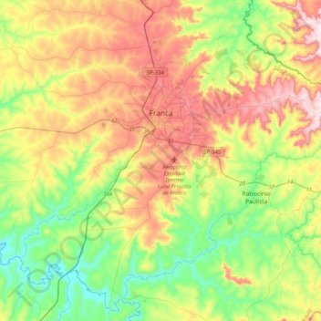
Nom : Carte topographique Franca, altitude, relief.
Altitude moyenne : 847 m
Altitude minimum : 630 m
Altitude maximum : 1 171 m
Faire un don
Équipez-vous pour votre prochaine aventure :
En tant que Partenaire Amazon, ce site perçoit une commission sur les achats éligibles sans surcoût pour vous.
Autres cartes topographiques
Cliquez sur une carte pour visualiser sa topographie, son altitude et son relief.
São Paulo
Brazil > São Paulo > Região Metropolitana de São Paulo > São Paulo
São Paulo is in Southeastern Brazil, in southeastern São Paulo State, approximately halfway between Curitiba and Rio de Janeiro. The city is on a plateau placed beyond the Serra do Mar (Portuguese for "Sea Range" or "Coastal Range"), itself a component of the vast region known as the Brazilian Highlands,…
Altitude moyenne : 785 m
Pedra do Baú
Brazil > São Paulo > Região Metropolitana do Vale do Paraíba e Litoral Norte > São Bento do Sapucaí
At its highest point, the elevation is 1,950 metres (6,400 ft).
Altitude moyenne : 1 502 m
Praça Tenente Roberto Osaki
Brazil > São Paulo > Região Metropolitana de São Paulo > Osasco
Altitude moyenne : 731 m
Ilha Sumítica
Brazil > São Paulo > Região Metropolitana do Vale do Paraíba e Litoral Norte > Ilhabela
Altitude moyenne : 1 m
Faire un don
Équipez-vous pour votre prochaine aventure :
En tant que Partenaire Amazon, ce site perçoit une commission sur les achats éligibles sans surcoût pour vous.
Ilha Sumítica
Brazil > São Paulo > Região Metropolitana do Vale do Paraíba e Litoral Norte > Ilhabela
Altitude moyenne : 1 m
Morro do Pico Agudo
Brazil > São Paulo > Região Metropolitana do Vale do Paraíba e Litoral Norte > Paraibuna
Altitude moyenne : 1 056 m
Praça Barão do Rio Branco
Brazil > São Paulo > Região Metropolitana do Vale do Paraíba e Litoral Norte > Jacareí
Altitude moyenne : 581 m
Kobayat Líbano
Brazil > São Paulo > Região Metropolitana de Piracicaba > Piracicaba
Altitude moyenne : 521 m
Faire un don
Équipez-vous pour votre prochaine aventure :
En tant que Partenaire Amazon, ce site perçoit une commission sur les achats éligibles sans surcoût pour vous.
Nova Piracicaba
Brazil > São Paulo > Região Metropolitana de Piracicaba > Piracicaba
Altitude moyenne : 493 m
Serra do Roncador
Brazil > São Paulo > Região Metropolitana do Vale do Paraíba e Litoral Norte > Monteiro Lobato
Altitude moyenne : 846 m
Ilha Sumítica
Brazil > São Paulo > Região Metropolitana do Vale do Paraíba e Litoral Norte > Ilhabela
Altitude moyenne : 1 m
Faire un don
Équipez-vous pour votre prochaine aventure :
En tant que Partenaire Amazon, ce site perçoit une commission sur les achats éligibles sans surcoût pour vous.
Morro do Diabo
Brazil > São Paulo > Teodoro Sampaio
Its summit altitude is 650 metres (2,130 ft) (ASL). Morro do Diabo is an area landmark, seen from the valleys and plains below it. It is located near the cities of Caxias do Sul and Porto Alegre, the state capital.
Altitude moyenne : 397 m
Sitio Borda da Mata
Brazil > São Paulo > Região Metropolitana de São Paulo > Franco da Rocha
Altitude moyenne : 793 m
Praça Bartolomeu de Messina
Brazil > São Paulo > Região Metropolitana de São Paulo > São Paulo
Altitude moyenne : 790 m
Faire un don
Équipez-vous pour votre prochaine aventure :
En tant que Partenaire Amazon, ce site perçoit une commission sur les achats éligibles sans surcoût pour vous.
Mirante Rio Piracicaba
Brazil > São Paulo > Região Metropolitana de Piracicaba > Piracicaba
Altitude moyenne : 505 m
Ilha da Queimada Grande
Located approximately 33 kilometres (21 mi) off the coast of the state of São Paulo, Brazil, the island of Queimada Grande is approximately 430,000 square metres (106 acres) in area and ranges in elevation from 0 to 206 metres (676 ft) above sea level. It has a temperate climate that is similar to that of its…
Altitude moyenne : 3 m
Paiol Grande
Brazil > São Paulo > Região Metropolitana do Vale do Paraíba e Litoral Norte > São Bento do Sapucaí
Altitude moyenne : 1 339 m
Faire un don
Équipez-vous pour votre prochaine aventure :
En tant que Partenaire Amazon, ce site perçoit une commission sur les achats éligibles sans surcoût pour vous.
Santo André
Brazil > São Paulo > Região Metropolitana de São Paulo > Santo André
Altitude moyenne : 776 m
Bairro Planalto do Sul
Brazil > São Paulo > Mirante do Paranapanema > Bairro Planalto do Sul
Altitude moyenne : 437 m
Faire un don
Équipez-vous pour votre prochaine aventure :
En tant que Partenaire Amazon, ce site perçoit une commission sur les achats éligibles sans surcoût pour vous.
Sorocaba
Brazil > São Paulo > Região Metropolitana de Sorocaba > Sorocaba
The terrain is classified as a wavy strands and characterized by local ridges, with an average altitude of 632 meters above the sea level. The highest altitude is 1028 meters, in the Serra de Sao Francisco. The lower altitude is 539 meters, in the valley of the Sorocaba River. Sorocaba is located on the edge…
Altitude moyenne : 662 m
São José dos Campos
Brazil > São Paulo > Região Metropolitana do Vale do Paraíba e Litoral Norte
In the urban area, there are rolling plateaus and hills. The lowest elevation in the city (and also in the municipality) is found in the Paraíba do Sul River, at a mean elevation of 550 m.
Altitude moyenne : 634 m
Faire un don
Équipez-vous pour votre prochaine aventure :
En tant que Partenaire Amazon, ce site perçoit une commission sur les achats éligibles sans surcoût pour vous.
São Bernardo do Campo
Brazil > São Paulo > Região Metropolitana de São Paulo > São Bernardo do Campo
Altitude moyenne : 760 m
Faire un don
Équipez-vous pour votre prochaine aventure :
En tant que Partenaire Amazon, ce site perçoit une commission sur les achats éligibles sans surcoût pour vous.
Rio Paraíba do Sul
Brazil > São Paulo > Região Metropolitana do Vale do Paraíba e Litoral Norte > Guaratinguetá
Altitude moyenne : 546 m
Mogi Mirim
Brazil > São Paulo > Mogi Mirim
Mogi Mirim is a municipality located in the eastern part of São Paulo State, in Brazil. The population is 93,650 (2020 est.) in an area of 498 km². The elevation is 611 m.
Altitude moyenne : 655 m