
Carte topographique Wuqi County
Carte interactive
Cliquez sur la carte pour afficher l’altitude.
Wuqi County
Wuqi is adjacent to Dingbian County in the northwest, Zhidan County in the southeast, Jingbian County in the northeast, and Huachi County in Gansu Province in the southwest. The county's two main rivers are the Wuding River and the Beiluo River. The region is largely hilly, with the terrain's altitude varying from 1,233 metres (4,045 ft) to 1,809 metres (5,935 ft) in height.
À propos de cette carte
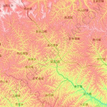
Nom : Carte topographique Wuqi County, altitude, relief.
Lieu : Wuqi County, Yan'an, Shaanxi, China (36.55928 107.65051 37.40758 108.54827)
Altitude moyenne : 1 524 m
Altitude minimum : 1 154 m
Altitude maximum : 1 900 m