
Carte topographique Naraingarh
Cliquez sur la carte pour afficher l’altitude.
Naraingarh
Naraingarh is located near the foothills of the Sivalik range of the Himalayas in northwest India. It covers an area of approximately 481 km2. It shares its borders with the states of Himachal Pradesh. The exact cartographic co-ordinates of Narayangarh are 30°28′N 77°08′E / 30.47°N 77.13°E / 30.47; 77.13.It has an average elevation of 325 metres (1065 ft).
À propos de cette carte
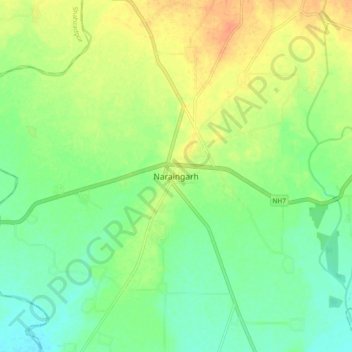
Nom : Carte topographique Naraingarh, altitude, relief.
Lieu : Naraingarh, Ambala, Haryana, 134203, India (30.43239 77.08427 30.51239 77.16427)
Altitude moyenne : 321 m
Altitude minimum : 305 m
Altitude maximum : 342 m