Géolocaliser

Carte topographique Scunthorpe

Cliquez sur la carte pour afficher l’altitude.

👉 Easily get elevation data in JSON, GeoTIFF and KML formats using Elevation API
Merci de soutenir ce site ❤️
Faire un don

À propos de cette carte

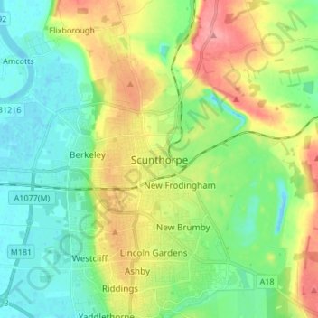
Nom : Carte topographique Scunthorpe, altitude, relief.

Lieu : Scunthorpe, North Lincolnshire, Greater Lincolnshire, England, DN15 6SS, United Kingdom (53.55225 -0.68508 53.63225 -0.60508)

Altitude moyenne : 28 m

Altitude minimum : -9 m

Altitude maximum : 78 m

Autres cartes topographiques

Cliquez sur une carte pour visualiser sa topographie, son altitude et son relief.

Brigg

United Kingdom > England > North Lincolnshire

Altitude moyenne : 6 m

Kirmington

United Kingdom > England > North Lincolnshire

Altitude moyenne : 38 m

Wootton

United Kingdom > England > North Lincolnshire

Altitude moyenne : 45 m

Bottesford

United Kingdom > England > North Lincolnshire

Altitude moyenne : 23 m

Bonby

United Kingdom > England > North Lincolnshire

Altitude moyenne : 34 m

Broughton

United Kingdom > England > North Lincolnshire

Altitude moyenne : 24 m

Winterton

United Kingdom > England > North Lincolnshire

Altitude moyenne : 19 m

Hibaldstow

United Kingdom > England > North Lincolnshire

Altitude moyenne : 19 m

Alkborough

United Kingdom > England > North Lincolnshire

Altitude moyenne : 18 m

Belton

United Kingdom > England > North Lincolnshire

Altitude moyenne : 4 m

Wroot

United Kingdom > England > North Lincolnshire

Altitude moyenne : 2 m

Appleby

United Kingdom > England > North Lincolnshire

Altitude moyenne : 19 m

Gunness

United Kingdom > England > North Lincolnshire

Altitude moyenne : 3 m

Worlaby

United Kingdom > England > North Lincolnshire

Altitude moyenne : 37 m

Haxey

United Kingdom > England > North Lincolnshire

The civil parish includes the town of Haxey and the village of Westwoodside, and the hamlets of Haxey Carr, High Burnham (the highest elevation of the Isle of Axholme), Low Burnham, East Lound, Graizelound and Upperthorpe which is conjoined to Westwoodside.

Altitude moyenne : 7 m

Horkstow

United Kingdom > England > North Lincolnshire

Altitude moyenne : 37 m

Alkborough

United Kingdom > England > North Lincolnshire

Altitude moyenne : 18 m

Epworth

United Kingdom > England > North Lincolnshire

Altitude moyenne : 6 m

Winterton

United Kingdom > England > North Lincolnshire

Altitude moyenne : 19 m

Winterton

United Kingdom > England > North Lincolnshire

Altitude moyenne : 19 m

Winterton

United Kingdom > England > North Lincolnshire

Altitude moyenne : 19 m

Équipez-vous pour votre prochaine aventure :

🧤Gants chauffants rechargeables - Le confort ultime pour la cartographie hivernale
🪢Cordes paracorde - Cordes polyvalentes pour camping et survie
🧥Doudoune compressible - Chaleur instantanée pour les pauses au sommet
🧰Outils multifonctions - Polyvalence et compacité
🧭Équipement d'orientation - Matériel pour course et navigation

En tant que Partenaire Amazon, ce site perçoit une commission sur les achats éligibles sans surcoût pour vous.