
Carte topographique Sierra Negra
Carte interactive
Cliquez sur la carte pour afficher l’altitude.
À propos de cette carte
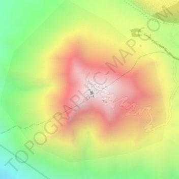
Nom : Carte topographique Sierra Negra, altitude, relief.
Lieu : Sierra Negra, Chalchicomula de Sesma, Puebla, Mexico (18.98616 -97.31515 18.98626 -97.31505)
Altitude moyenne : 4 099 m
Altitude minimum : 3 534 m
Altitude maximum : 4 575 m
Sierra Negra is located within the Pico de Orizaba National Park. The mountain is the site for two of the world's premier astronomical instruments, the Large Millimeter Telescope and the High Altitude Water Cherenkov Observatory. Therefore, the access to the mountain is restricted and has to be applied for at least a week in advance. The service road for this facility is claimed to be the highest road in North America. A part of the telescope facility is visible as a white dot in the first picture below and more clearly in the second picture.
Autres cartes topographiques
Cliquez sur une carte pour visualiser sa topographie, son altitude et son relief.
Pico de Orizaba
Mexico > Puebla > Chalchicomula de Sesma
Pico de Orizaba, Chalchicomula de Sesma, Puebla, Mexico
Altitude moyenne : 4 967 m