
Carte topographique Hertfordshire
Carte interactive
Cliquez sur la carte pour afficher l’altitude.
À propos de cette carte
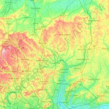
Nom : Carte topographique Hertfordshire, altitude, relief.
Lieu : Hertfordshire, England, United Kingdom (51.59958 -0.74579 52.08054 0.19557)
Altitude moyenne : 82 m
Altitude minimum : 4 m
Altitude maximum : 243 m
Elevations are higher in the north and west, reaching more than 800 feet (240 m) in the Chilterns near Tring. The county centres on the headwaters and upper valleys of the rivers Lea and the Colne; both flow south, and each is accompanied by a canal. Hertfordshire's undeveloped land is mainly agricultural, with much of it protected by green-belt policies. Services have become the largest sector of the county's economy. Hertfordshire is well served with motorways and railways for access to London, the Midlands and the North.
Autres cartes topographiques
Cliquez sur une carte pour visualiser sa topographie, son altitude et son relief.
London
United Kingdom > England > London
London, Greater London, England, SW1A 2DX, United Kingdom
Altitude moyenne : 42 m
Bristol
United Kingdom > England > City of Bristol
Bristol, City of Bristol, West of England, England, United Kingdom
Altitude moyenne : 55 m
London
London, Greater London, England, United Kingdom
Altitude moyenne : 66 m
Greater Manchester
Greater Manchester, England, United Kingdom
Altitude moyenne : 141 m
Newcastle upon Tyne
Newcastle upon Tyne, North of Tyne, England, United Kingdom
Altitude moyenne : 57 m
Lake District National Park
Lake District National Park, England, United Kingdom
Altitude moyenne : 206 m
Greater London
Greater London, England, United Kingdom
Altitude moyenne : 66 m
Northamptonshire
Northamptonshire, England, United Kingdom
Altitude moyenne : 97 m
Liverpool
Liverpool, Liverpool City Region, England, United Kingdom
Altitude moyenne : 26 m
Coventry
Coventry, West Midlands Combined Authority, England, United Kingdom
Altitude moyenne : 99 m
Castleton
United Kingdom > England > Derbyshire > High Peak
Castleton, High Peak, Derbyshire, England, United Kingdom
Altitude moyenne : 326 m
South East England
South East England, England, United Kingdom
Altitude moyenne : 69 m
West Midlands
United Kingdom > England > Warwickshire
West Midlands, Warwickshire, West Midlands Combined Authority, England, United Kingdom
Altitude moyenne : 113 m
Kingston upon Thames
Kingston upon Thames, Greater London, England, KT1 1JS, United Kingdom
Altitude moyenne : 19 m
Hull
United Kingdom > England > Kingston upon Hull
Hull, Kingston upon Hull, England, HU1 3RJ, United Kingdom
Altitude moyenne : 21 m
Brighton
United Kingdom > England > Brighton and Hove
Brighton, Brighton and Hove, England, United Kingdom
Altitude moyenne : 64 m
Eastbourne
United Kingdom > England > East Sussex
Eastbourne, East Sussex, England, United Kingdom
Altitude moyenne : 36 m
Corby
United Kingdom > England > North Northamptonshire > Corby
Corby, North Northamptonshire, East Midlands, England, United Kingdom
Altitude moyenne : 98 m
Sheffield
Sheffield, South Yorkshire, England, United Kingdom
Altitude moyenne : 168 m
Cold Higham
United Kingdom > England > West Northamptonshire
Cold Higham, West Northamptonshire, England, United Kingdom
Altitude moyenne : 131 m
Kent
United Kingdom > England > Sevenoaks
Kent, Beechenlea Lane, Swanley, Sevenoaks, Kent, South East, England, BR8 7PR, United Kingdom
Altitude moyenne : 37 m
Lincolnshire
Lincolnshire, East Midlands, England, United Kingdom
Altitude moyenne : 28 m
Leicestershire
Leicestershire, East Midlands, England, United Kingdom
Altitude moyenne : 97 m
Dorking
United Kingdom > England > Surrey > Mole Valley
Dorking, Mole Valley, Surrey, England, United Kingdom
Altitude moyenne : 80 m
Cambridge
United Kingdom > England > Cambridge
Cambridge, Cambridgeshire, East of England, England, United Kingdom
Altitude moyenne : 18 m
East Riding of Yorkshire
East Riding of Yorkshire, England, United Kingdom
Altitude moyenne : 30 m
Newark on Trent
United Kingdom > England > Nottinghamshire > Newark and Sherwood
Newark on Trent, Newark and Sherwood, Nottinghamshire, England, NG24 1EJ, United Kingdom
Altitude moyenne : 18 m
Skipton
United Kingdom > England > Skipton
Skipton, North Yorkshire, Yorkshire and the Humber, England, BD23 1DU, United Kingdom
Altitude moyenne : 201 m
Enfield
United Kingdom > England > London
Enfield, Greater London, England, EN2 6LD, United Kingdom
Altitude moyenne : 39 m
Lancaster
United Kingdom > England > Lancashire
Lancaster, Lancashire, England, United Kingdom
Altitude moyenne : 84 m
Barrow-in-Furness
United Kingdom > England > Westmorland and Furness > Stank
Barrow-in-Furness, Stank, Westmorland and Furness, England, United Kingdom
Altitude moyenne : 22 m
St Albans
United Kingdom > England > Hertfordshire > St Albans
St Albans, Hertfordshire, East of England, England, United Kingdom
Altitude moyenne : 100 m
Birmingham
Birmingham, West Midlands Combined Authority, England, United Kingdom
Altitude moyenne : 138 m
Swindon
United Kingdom > England > Swindon
Swindon, England, SN1 1LF, United Kingdom
Altitude moyenne : 108 m
Peterborough
United Kingdom > England > City of Peterborough
Peterborough, City of Peterborough, Cambridgeshire and Peterborough, England, PE1 1XH, United Kingdom
Altitude moyenne : 17 m
Durham
United Kingdom > England > County Durham
Durham, County Durham, North East, England, DH1 3NG, United Kingdom
Altitude moyenne : 119 m
North Norfolk
United Kingdom > England > Norfolk
North Norfolk, Norfolk, England, United Kingdom
Altitude moyenne : 26 m
Yorkshire Dales National Park
Yorkshire Dales National Park, England, United Kingdom
Altitude moyenne : 298 m