
Carte topographique Clifton upon Dunsmore CP
Carte interactive
Cliquez sur la carte pour afficher l’altitude.
À propos de cette carte
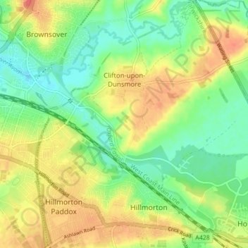
Nom : Carte topographique Clifton upon Dunsmore CP, altitude, relief.
Altitude moyenne : 108 m
Altitude minimum : 85 m
Altitude maximum : 134 m
Autres cartes topographiques
Cliquez sur une carte pour visualiser sa topographie, son altitude et son relief.
Draycote Water
United Kingdom > England > Warwickshire > Rugby > Draycote
Draycote Water, Draycote, Rugby, Warwickshire, England, United Kingdom
Altitude moyenne : 92 m
Newton
United Kingdom > England > Warwickshire > Rugby
Newton, Rugby, Warwickshire, England, CV23 0EE, United Kingdom
Altitude moyenne : 114 m
Newbold on Avon
United Kingdom > England > Warwickshire > Rugby
Newbold on Avon, Rugby, Warwickshire, England, CV21 1HQ, United Kingdom
Altitude moyenne : 98 m