
Carte topographique Village of Evans Mills
Carte interactive
Cliquez sur la carte pour afficher l’altitude.
À propos de cette carte
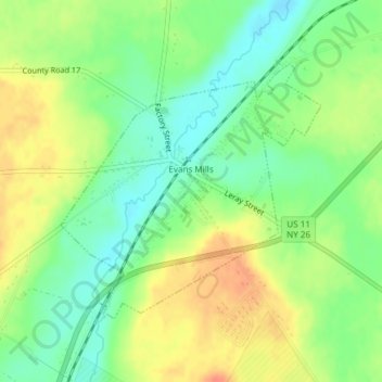
Nom : Carte topographique Village of Evans Mills, altitude, relief.
Altitude moyenne : 139 m
Altitude minimum : 118 m
Altitude maximum : 163 m
Autres cartes topographiques
Cliquez sur une carte pour visualiser sa topographie, son altitude et son relief.
Just Room Enough Island
United States > New York > Jefferson County > Village of Alexandria Bay
Just Room Enough Island, Village of Alexandria Bay, Town of Alexandria, Jefferson County, New York, United States
Altitude moyenne : 78 m
Town of Watertown
United States > New York > Jefferson County
Town of Watertown, Jefferson County, New York, United States
Altitude moyenne : 189 m
Village of Black River
United States > New York > Jefferson County
Village of Black River, Town of Le Ray, Jefferson County, New York, United States
Altitude moyenne : 193 m
Village of Philadelphia
United States > New York > Jefferson County
Village of Philadelphia, Town of Philadelphia, Jefferson County, New York, 13673, United States
Altitude moyenne : 149 m
Village of Theresa
United States > New York > Jefferson County > Town of Theresa
Village of Theresa, Town of Theresa, Jefferson County, New York, 13691, United States
Altitude moyenne : 121 m
Black River
United States > New York > Jefferson County > Black River
Black River, Le Ray, Jefferson County, New York, 13612, United States
Altitude moyenne : 189 m
Whites Bay
United States > New York > Jefferson County
Whites Bay, Henderson, Jefferson County, New York, 13651, United States
Altitude moyenne : 91 m