
Faire un don
Équipez-vous pour votre prochaine aventure :
En tant que Partenaire Amazon, ce site perçoit une commission sur les achats éligibles sans surcoût pour vous.
Carte topographique Easton
Cliquez sur la carte pour afficher l’altitude.
Faire un don
Équipez-vous pour votre prochaine aventure :
En tant que Partenaire Amazon, ce site perçoit une commission sur les achats éligibles sans surcoût pour vous.
Easton
Easton (formerly, Covel and Covell) is a census-designated place (CDP) in Fresno County, California, United States. The population was 2,083 at the 2010 census, up from 1,966 at the 2000 census. Easton is located 7.5 miles (12.1 km) south of downtown Fresno, at an elevation of 276 feet (84 m).
Faire un don
Équipez-vous pour votre prochaine aventure :
En tant que Partenaire Amazon, ce site perçoit une commission sur les achats éligibles sans surcoût pour vous.
À propos de cette carte
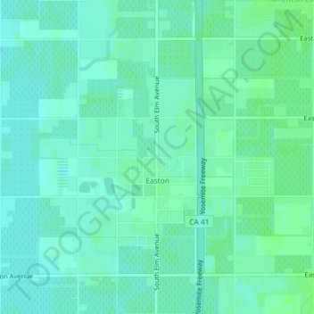
Nom : Carte topographique Easton, altitude, relief.
Lieu : Easton, Fresno County, California, United States (36.64142 -119.80882 36.66336 -119.77276)
Altitude moyenne : 85 m
Altitude minimum : 81 m
Altitude maximum : 89 m
Faire un don
Équipez-vous pour votre prochaine aventure :
En tant que Partenaire Amazon, ce site perçoit une commission sur les achats éligibles sans surcoût pour vous.
Autres cartes topographiques
Cliquez sur une carte pour visualiser sa topographie, son altitude et son relief.
Pinedale
United States > California > Fresno County > Fresno
Pinedale is a previously unincorporated community in Fresno County, California. It lies at an elevation of 348 feet (106 m). It was once a rural community located on the Southern Pacific Railroad 3.5 miles (5.6 km) north-northwest of Clovis but has since become surrounded and annexed by the city of Fresno.…
Altitude moyenne : 107 m
Yokuts Valley
United States > California > Fresno County
As of the 2010 census, the CDP had a total population of 3,162, up from 2,691 at the 2000 census. Yokuts Valley is located 9 miles (14 km) north-northeast of Orange Cove and 30 miles (48 km) east of Fresno, at an elevation of 1,631 ft (497 m).
Altitude moyenne : 551 m
Burrel
United States > California > Fresno County
Burrel (formerly, Burrell) is an unincorporated community in Fresno County, California. It is located 30 miles (48 km) southwest of Fresno, at an elevation of 203 feet (62 m).
Altitude moyenne : 61 m
Faire un don
Équipez-vous pour votre prochaine aventure :
En tant que Partenaire Amazon, ce site perçoit une commission sur les achats éligibles sans surcoût pour vous.
Tranquillity
United States > California > Fresno County
Tranquillity is a census-designated place (CDP) in Fresno County, California, United States. It is located 10 miles (16 km) southeast of Mendota, at an elevation of 164 feet (50 m). The population was 799 at the 2010 census, down from 813 at the 2000 census. Tranquillity High School is the only high school in…
Altitude moyenne : 49 m
Faire un don
Équipez-vous pour votre prochaine aventure :
En tant que Partenaire Amazon, ce site perçoit une commission sur les achats éligibles sans surcoût pour vous.
Monmouth
United States > California > Fresno County
Monmouth is a census-designated place in Fresno County, California. It is located 7.25 miles (12 km) west of Selma, at an elevation of 276 feet (84 m). At the 2010 census, Monmouth had a population of 152.
Altitude moyenne : 84 m
Minkler
United States > California > Fresno County
Minkler is a census-designated place in eastern Fresno County, California. The place is located on Highway 180, 2.25 miles (3.6 km) east-southeast of Centerville and 7.6 miles north of Reedley at an elevation of 397 feet (121 m). It has a population of 1,003 people. The town is named for Charles O. Minkler, a…
Altitude moyenne : 130 m
Laton
United States > California > Fresno County
Laton /ˈleɪtən/ is a census-designated place (CDP) in Fresno County, California, United States. The population was 1,824 at the 2010 census, up from 1,236 at the 2000 census. Laton is located 23 miles (37 km) south-southeast of Fresno, at an elevation of 259 feet (79 m).
Altitude moyenne : 79 m
Orange Cove
United States > California > Fresno County
Almost all of Orange Cove's residents are Hispanic, many of them farmers. Orange Cove is located in the San Joaquin Valley, 8 miles (13 km) east-northeast of Reedley, at an elevation of 423 feet (129 m).
Altitude moyenne : 132 m
Faire un don
Équipez-vous pour votre prochaine aventure :
En tant que Partenaire Amazon, ce site perçoit une commission sur les achats éligibles sans surcoût pour vous.
Shaver Lake Heights
United States > California > Fresno County > Shaver Lake
Altitude moyenne : 1 667 m
Kaiser Wilderness
United States > California > Fresno County
The Kaiser Wilderness stretches along an east–west ridge and is separated from the High Sierra by the South Fork San Joaquin River canyon. It is a miniature version of the Sierra, with elevations from 7,200 feet (2,200 m) to 10,320 feet (3,150 m) at Kaiser Peak, and is composed of glacier-scoured granite…
Altitude moyenne : 2 267 m
Faire un don
Équipez-vous pour votre prochaine aventure :
En tant que Partenaire Amazon, ce site perçoit une commission sur les achats éligibles sans surcoût pour vous.
Yokuts Valley
United States > California > Fresno County
Yokuts Valley (formerly, Squaw Valley) is a census-designated place located in Fresno County, California, in the United States. As of the 2010 census, the CDP had a total population of 3,162, up from 2,691 at the 2000 census. Yokuts Valley is located 9 miles (14 km) north-northeast of Orange Cove and 30 miles…
Altitude moyenne : 437 m
Faire un don
Équipez-vous pour votre prochaine aventure :
En tant que Partenaire Amazon, ce site perçoit une commission sur les achats éligibles sans surcoût pour vous.
Shaver Lake
United States > California > Fresno County
Shaver Lake (formerly, Musick Creek and Musick Creek Heights) is a census-designated place (CDP) in Fresno County, California, United States. The population was 634 at the 2010 census, down from 705 at the 2000 census. Shaver Lake is on the southwest end of the lake of the same name, 10 miles (16 km) east of…
Altitude moyenne : 1 563 m
Faire un don
Équipez-vous pour votre prochaine aventure :
En tant que Partenaire Amazon, ce site perçoit une commission sur les achats éligibles sans surcoût pour vous.
Kingsburg
United States > California > Fresno County
Kingsburg is a city in Fresno County, California. Kingsburg is located 5 miles (8 km) southeast of Selma at an elevation of 302 feet (92 m), on the banks of the Kings River. The city is 21 miles (34 km) from Fresno, and about 130 miles (210 km) from the California Central Coast and Sierra Nevada mountain…
Altitude moyenne : 93 m
Riverdale
United States > California > Fresno County
Riverdale (formerly, Liberty Settlement) is a census-designated place (CDP) in Fresno County, California, United States. The population was 3,153 at the 2010 census, up from 2,416 at the 2000 census. Riverdale is located 23 miles (37 km) south of Fresno, at an elevation of 223 ft (68 m).
Altitude moyenne : 67 m
Faire un don
Équipez-vous pour votre prochaine aventure :
En tant que Partenaire Amazon, ce site perçoit une commission sur les achats éligibles sans surcoût pour vous.
San Joaquin
United States > California > Fresno County
San Joaquin (Spanish: San Joaquín, meaning "St. Joachim") is a city in Fresno County, California, United States. The population was 4,001 at the 2010 census, up from 3,270 at the 2000 census. The nearest high school in the area is Tranquillity High School in Tranquillity. San Joaquin is located 11 miles (18…
Altitude moyenne : 52 m
Faire un don
Équipez-vous pour votre prochaine aventure :
En tant que Partenaire Amazon, ce site perçoit une commission sur les achats éligibles sans surcoût pour vous.