
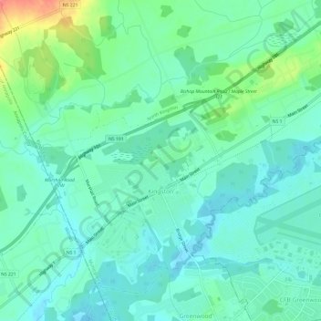
Carte topographique Kingston
Carte interactive
Cliquez sur la carte pour afficher l’altitude.
À propos de cette carte
Nom : Carte topographique Kingston, altitude, relief.
Altitude moyenne : 30 m
Altitude minimum : 13 m
Altitude maximum : 82 m
Autres cartes topographiques
Cliquez sur une carte pour visualiser sa topographie, son altitude et son relief.
Blue Mountain
Canada > Nova Scotia > Municipality of the County of Kings
Blue Mountain, Municipality of the County of Kings, Kings County, Nova Scotia, B4N 3V8, Canada
Altitude moyenne : 224 m
Dalhousie Road
Canada > Nova Scotia > Municipality of the County of Kings
Dalhousie Road, East Dalhousie, Municipality of the County of Kings, Kings County, Nova Scotia, B0R 1H0, Canada
Altitude moyenne : 207 m
Mountain Front
Canada > Nova Scotia > Municipality of the County of Kings
Mountain Front, Municipality of the County of Kings, Kings County, Nova Scotia, Canada
Altitude moyenne : 166 m
Lake George
Canada > Nova Scotia > Municipality of the County of Kings
Lake George, Municipality of the County of Kings, Kings County, Nova Scotia, B0P 1C0, Canada
Altitude moyenne : 227 m
Ogilvie
Canada > Nova Scotia > Municipality of the County of Kings
Ogilvie, Municipality of the County of Kings, Kings County, Nova Scotia, B0P 1E0, Canada
Altitude moyenne : 41 m
Ross Creek
Canada > Nova Scotia > Municipality of the County of Kings
Ross Creek, Municipality of the County of Kings, Kings County, Nova Scotia, B0P 1H0, Canada
Altitude moyenne : 100 m