
Carte topographique Celica
Carte interactive
Cliquez sur la carte pour afficher l’altitude.
À propos de cette carte
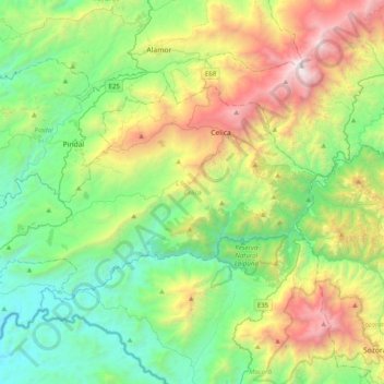
Nom : Carte topographique Celica, altitude, relief.
Lieu : Celica, Loja, 110401, Ecuador (-4.27717 -80.24102 -4.05255 -79.84508)
Altitude moyenne : 1 088 m
Altitude minimum : 200 m
Altitude maximum : 3 070 m
Celica is a canton in Loja Province, Ecuador. Its seat is Celica. The canton is located in the west of the province and is bordered by the cantons of Puyango and Paltas in the north, Sozoranga in the east, Macará in the south, and Pindal and Zapotillo in the west. It covers 521.9 km2 at an altitude of 2,500 m.
Autres cartes topographiques
Cliquez sur une carte pour visualiser sa topographie, son altitude et son relief.
Algarrobillo
Algarrobillo, Tnte. Maximiliano Rodriguez Loaiza, Celica, Loja, Ecuador
Altitude moyenne : 888 m
Cordillera del Huato
Cordillera del Huato, Catacocha, Paltas, Loja, Ecuador
Altitude moyenne : 1 268 m
Quebrada Limón
Quebrada Limón, Cantón Sozoranga, Loja, Ecuador
Altitude moyenne : 1 402 m