
Carte topographique Taüll
Carte interactive
Cliquez sur la carte pour afficher l’altitude.
À propos de cette carte
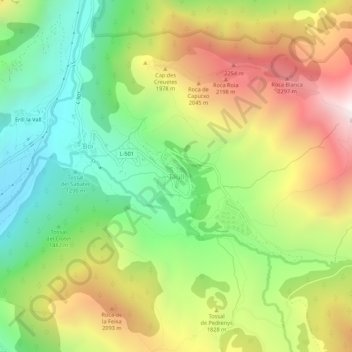
Nom : Carte topographique Taüll, altitude, relief.
Altitude moyenne : 1 707 m
Altitude minimum : 1 115 m
Altitude maximum : 2 498 m
Located at an altitude of 1,520 meters in the Sant Martí valley, a small valley in the Valley of Boí. The closest river is the Sant Martí river, Noguera de Tor affluent. A ravine splits the village in two districts: La Guinsa and Lo Barri. La Guinsa goes from the entrance of the village to the ravine, and Lo Barri goes from the ravine to the high part of the village.
Autres cartes topographiques
Cliquez sur une carte pour visualiser sa topographie, son altitude et son relief.
Erill la Vall
Spain > Catalonia > Alta Ribagorça > la Vall de Boí > Boí
Erill la Vall, Boí, la Vall de Boí, Alta Ribagorça, Catalonia, 25528, Spain
Altitude moyenne : 1 599 m