
Carte topographique Zell (Mosel)
Carte interactive
Cliquez sur la carte pour afficher l’altitude.
À propos de cette carte
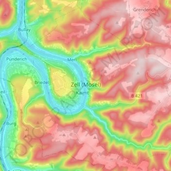
Nom : Carte topographique Zell (Mosel), altitude, relief.
Altitude moyenne : 287 m
Altitude minimum : 89 m
Altitude maximum : 458 m
Zell is an hour's drive from both Koblenz and Trier, more or less halfway between these two cities. The nearest town going towards Koblenz is Cochem, and the nearest two going towards Trier are Traben-Trarbach and Bernkastel-Kues. To both Frankfurt-Hahn Airport on the Hunsrück and the spa town of Bad Bertrich in the Voreifel it is half an hour's drive. The parts of town lying on the river, the Old Town, Kaimt and Merl, are at an elevation of roughly 100 m above sea level on a remarkable bow in the river Moselle, known as the Zeller Hamm.
Autres cartes topographiques
Cliquez sur une carte pour visualiser sa topographie, son altitude et son relief.
Bullay
Germany > Rhineland-Palatinate > Landkreis Cochem-Zell
Bullay, Zell (Mosel), Landkreis Cochem-Zell, Rhineland-Palatinate, Germany
Altitude moyenne : 207 m
Ulmen
Germany > Rhineland-Palatinate > Landkreis Cochem-Zell
Ulmen, Landkreis Cochem-Zell, Rhineland-Palatinate, 56766, Germany
Altitude moyenne : 455 m
Moselhöhe Ediger-Eller
Germany > Rhineland-Palatinate > Landkreis Cochem-Zell > Ediger-Eller
Moselhöhe Ediger-Eller, Ediger-Eller, Cochem, Landkreis Cochem-Zell, Rhineland-Palatinate, 56814, Germany
Altitude moyenne : 285 m
Cochem
Germany > Rhineland-Palatinate > Landkreis Cochem-Zell
Cochem, Landkreis Cochem-Zell, Rhineland-Palatinate, Germany
Altitude moyenne : 286 m
Beilstein
Germany > Rhineland-Palatinate > Landkreis Cochem-Zell
Beilstein, Cochem, Landkreis Cochem-Zell, Rhineland-Palatinate, Germany
Altitude moyenne : 234 m
Bremm
Germany > Rhineland-Palatinate > Landkreis Cochem-Zell
Bremm, Cochem, Landkreis Cochem-Zell, Rhineland-Palatinate, Germany
Altitude moyenne : 258 m
Neef
Germany > Rhineland-Palatinate > Landkreis Cochem-Zell > Neef
Neef, Zell (Mosel), Landkreis Cochem-Zell, Rhineland-Palatinate, Germany
Altitude moyenne : 213 m