
Carte topographique Orange River
Carte interactive
Cliquez sur la carte pour afficher l’altitude.
À propos de cette carte
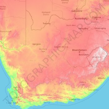
Nom : Carte topographique Orange River, altitude, relief.
Lieu : Orange River, 8850, South Africa (-30.69413 16.44945 -28.03360 29.07203)
Altitude moyenne : 967 m
Altitude minimum : 0 m
Altitude maximum : 3 373 m
During the temperate months of March and April, given good rains and the sluices of the dams being open, a canoeist (or rafter) can easily travel 30 km per day. The lower reaches of the river are most popular, because of the spectacular topography. Commercial tours are available, and these expeditions depart from the border town of Vioolsdrif.
Autres cartes topographiques
Cliquez sur une carte pour visualiser sa topographie, son altitude et son relief.
Carnarvon
South Africa > Northern Cape > Pixley ka Seme District Municipality > Kareeberg Local Municipality
Carnarvon, Kareeberg Local Municipality, Pixley ka Seme District Municipality, Northern Cape, 8925, South Africa
Altitude moyenne : 1 272 m
Sol Plaatje Local Municipality
South Africa > Northern Cape > Frances Baard District Municipality
Sol Plaatje Local Municipality, Frances Baard District Municipality, Northern Cape, South Africa
Altitude moyenne : 1 122 m
Upington
South Africa > Northern Cape > ZF Mgcawu District Municipality
Upington, ǁKhara Hais Local Municipality, ZF Mgcawu District Municipality, Northern Cape, 8801, South Africa
Altitude moyenne : 849 m
Hopetown
South Africa > Northern Cape > Pixley ka Seme District Municipality > Thembelihle Local Municipality
Hopetown, Thembelihle Local Municipality, Pixley ka Seme District Municipality, Northern Cape, South Africa
Altitude moyenne : 1 101 m
Kimberley
South Africa > Northern Cape > Frances Baard District Municipality > Kimberley
Kimberley, Frances Baard District Municipality, Northern Cape, 8301, South Africa
Altitude moyenne : 1 191 m
Joe Morolong Local Municipality
South Africa > Northern Cape > Joe Morolong Local Municipality
Joe Morolong Local Municipality, John Taolo Gaetsewe District Municipality, Northern Cape, 8460, South Africa
Altitude moyenne : 1 074 m
Philipstown
South Africa > Northern Cape > Philipstown
Philipstown, Pixley ka Seme District Municipality, Northern Cape, South Africa
Altitude moyenne : 1 382 m
Mariba
South Africa > Northern Cape > Mariba
Mariba, John Taolo Gaetsewe District Municipality, Northern Cape, South Africa
Altitude moyenne : 1 390 m
Kimberley
South Africa > Northern Cape > Frances Baard District Municipality
Kimberley, Sol Plaatje Local Municipality, Frances Baard District Municipality, Northern Cape, South Africa
Altitude moyenne : 1 203 m
Springbok
South Africa > Northern Cape > Springbok
Springbok, Namakwa District Municipality, Northern Cape, 8240, South Africa
Altitude moyenne : 926 m