
Carte topographique North District
Carte interactive
Cliquez sur la carte pour afficher l’altitude.
À propos de cette carte
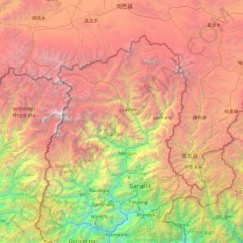
Nom : Carte topographique North District, altitude, relief.
Lieu : North District, North Sikkim District, Sikkim, India (27.02667 87.86000 28.30667 89.14000)
Altitude moyenne : 3 842 m
Altitude minimum : 269 m
Altitude maximum : 8 489 m
Autres cartes topographiques
Cliquez sur une carte pour visualiser sa topographie, son altitude et son relief.
Zemu Glacier
India > Sikkim > Chungthang
Zemu Glacier, Chungthang, Mangan District, Sikkim, India
Altitude moyenne : 5 510 m
Chungthang
Chungthang, Mangan District, Sikkim, 737120, India
Altitude moyenne : 4 598 m