
Carte topographique Crooksville
Carte interactive
Cliquez sur la carte pour afficher l’altitude.
À propos de cette carte
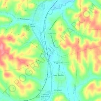
Nom : Carte topographique Crooksville, altitude, relief.
Lieu : Crooksville, Perry County, Ohio, United States (39.74069 -82.10996 39.78290 -82.08197)
Altitude moyenne : 261 m
Altitude minimum : 220 m
Altitude maximum : 319 m
Autres cartes topographiques
Cliquez sur une carte pour visualiser sa topographie, son altitude et son relief.
Glenford
United States > Ohio > Perry County
Glenford, Perry County, Ohio, United States
Altitude moyenne : 273 m
Portersville
United States > Ohio > Perry County
Portersville, Perry County, Ohio, United States
Altitude moyenne : 302 m
Corning
United States > Ohio > Perry County
Corning, Perry County, Ohio, United States
Altitude moyenne : 254 m
Shawnee
United States > Ohio > Perry County
Shawnee, Perry County, Ohio, 43782, United States
Altitude moyenne : 278 m
New Straitsville
United States > Ohio > Perry County
New Straitsville, Perry County, Ohio, United States
Altitude moyenne : 278 m
Mount Perry
United States > Ohio > Perry County
Mount Perry, Perry County, Ohio, 43760, United States
Altitude moyenne : 273 m
Glass Rock
United States > Ohio > Perry County
Glass Rock, Perry County, Ohio, 43739, United States
Altitude moyenne : 283 m
New Lexington
United States > Ohio > Perry County
New Lexington, Perry County, Ohio, United States
Altitude moyenne : 279 m