
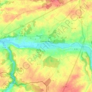
Carte topographique Concremiers
Carte interactive
Cliquez sur la carte pour afficher l’altitude.
À propos de cette carte
Nom : Carte topographique Concremiers, altitude, relief.
Altitude moyenne : 112 m
Altitude minimum : 78 m
Altitude maximum : 141 m
Autres cartes topographiques
Cliquez sur une carte pour visualiser sa topographie, son altitude et son relief.
Valençay
France > Centre-Val de Loire > Indre
Valençay, Châteauroux, Indre, Centre-Val de Loire, Metropolitan France, 36600, France
Altitude moyenne : 131 m
Langé
France > Centre-Val de Loire > Indre
Langé, Châteauroux, Indre, Centre-Val de Loire, Metropolitan France, 36600, France
Altitude moyenne : 143 m
Gournay
France > Centre-Val de Loire > Indre
Gournay, La Châtre, Indre, Centre-Val de Loire, Metropolitan France, 36230, France
Altitude moyenne : 206 m
Champ de Crozon
France > Centre-Val de Loire > Indre > Crozon-sur-Vauvre
Champ de Crozon, Bévet, Crozon-sur-Vauvre, La Châtre, Indre, Centre-Val de Loire, Metropolitan France, 36140, France
Altitude moyenne : 318 m
Les Illions
France > Centre-Val de Loire > Indre > Buzançais > Saint-Étienne
Les Illions, Saint-Étienne, Buzançais, Châteauroux, Indre, Centre-Val de Loire, Metropolitan France, 36500, France
Altitude moyenne : 117 m
Buzançais
France > Centre-Val de Loire > Indre
Buzançais, Châteauroux, Indre, Centre-Val de Loire, Metropolitan France, 36500, France
Altitude moyenne : 130 m
Briantes
France > Centre-Val de Loire > Indre
Briantes, La Châtre, Indre, Centre-Val de Loire, Metropolitan France, 36400, France
Altitude moyenne : 251 m
Saint-Plantaire
France > Centre-Val de Loire > Indre
Saint-Plantaire, La Châtre, Indre, Centre-Val de Loire, Metropolitan France, 36190, France
Altitude moyenne : 295 m
La Broue
France > Centre-Val de Loire > Indre > Cuzion
La Broue, Cuzion, Châteauroux, Indre, Centre-Val de Loire, Metropolitan France, 36190, France
Altitude moyenne : 260 m
Champarnoux
France > Centre-Val de Loire > Indre > Saint-Plantaire
Champarnoux, Saint-Plantaire, La Châtre, Indre, Centre-Val de Loire, Metropolitan France, 36190, France
Altitude moyenne : 265 m
Éguzon-Chantôme
France > Centre-Val de Loire > Indre
Éguzon-Chantôme, Châteauroux, Indre, Centre-Val de Loire, Metropolitan France, 36270, France
Altitude moyenne : 264 m
Le Blanc
France > Centre-Val de Loire > Indre
Le Blanc, Indre, Centre-Val de Loire, Metropolitan France, 36300, France
Altitude moyenne : 111 m
Montlevicq
France > Centre-Val de Loire > Indre > Montlevicq
Montlevicq, La Châtre, Indre, Centre-Val de Loire, Metropolitan France, 36400, France
Altitude moyenne : 230 m
Lacs
France > Centre-Val de Loire > Indre
Lacs, La Châtre, Indre, Centre-Val de Loire, Metropolitan France, 36400, France
Altitude moyenne : 224 m
Crozon-sur-Vauvre
France > Centre-Val de Loire > Indre
Crozon-sur-Vauvre, La Châtre, Indre, Centre-Val de Loire, Metropolitan France, 36140, France
Altitude moyenne : 348 m
La Morijo
France > Centre-Val de Loire > Indre > Cuzion > La Jarrige
La Morijo, La Jarrige, Cuzion, Châteauroux, Indre, Centre-Val de Loire, Metropolitan France, 36190, France
Altitude moyenne : 226 m
Fontgombault
France > Centre-Val de Loire > Indre
Fontgombault, Le Blanc, Indre, Centre-Val de Loire, Metropolitan France, 36220, France
Altitude moyenne : 112 m
Saint-Gaultier
France > Centre-Val de Loire > Indre
Saint-Gaultier, Le Blanc, Indre, Centre-Val de Loire, Metropolitan France, 36800, France
Altitude moyenne : 134 m
Châteauroux
France > Centre-Val de Loire > Indre > Châteauroux
Châteauroux, Indre, Centre-Val de Loire, Metropolitan France, 36000, France
Altitude moyenne : 153 m