
Carte topographique Farthing Corner
Cliquez sur la carte pour afficher l’altitude.
À propos de cette carte
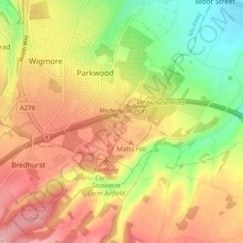
Nom : Carte topographique Farthing Corner, altitude, relief.
Altitude moyenne : 99 m
Altitude minimum : 26 m
Altitude maximum : 161 m
Autres cartes topographiques
Cliquez sur une carte pour visualiser sa topographie, son altitude et son relief.
Rainham Creek
United Kingdom > England > Medway > Gillingham > Lower Rainham > Motney Hill
Altitude moyenne : 4 m