
Carte topographique Corregidor Island
Carte interactive
Cliquez sur la carte pour afficher l’altitude.
À propos de cette carte
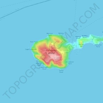
Nom : Carte topographique Corregidor Island, altitude, relief.
Altitude moyenne : 11 m
Altitude minimum : -1 m
Altitude maximum : 180 m
The tadpole-shaped island, with its tail running eastward, is about 6.5 km (4.0 mi) long, about 2.0 km (1.2 mi) wide at its widest with a total land area of about 900 hectares (2,200 acres). The highest elevation is at 180 m (590 ft) on the Topside. The island is divided into four sections:
Autres cartes topographiques
Cliquez sur une carte pour visualiser sa topographie, son altitude et son relief.
Cavite City
Philippines > Cavite > Cavite City
Cavite City, Cavite, Calabarzon, 4100, Philippines
Altitude moyenne : 13 m