Géolocaliser

Carte topographique Dhanbad

Cliquez sur la carte pour afficher l’altitude.

Dhanbad

Dhanbad has an average elevation of 227 m (745 ft). Its geographical length (extending from north to south) is 15 miles (24 km) and the breadth (stretching across east to West) is 10 miles (16 km). It shares its boundaries with West Bengal in the eastern and southern part, Dumka and Giridih in the North and Bokaro District in the west. Dhanbad comes under the Chota Nagpur Plateau.

Wikipedia (CC-BY-SA 3.0)

À propos de cette carte

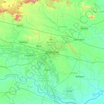
Nom : Carte topographique Dhanbad, altitude, relief.

Lieu : Dhanbad, Dhanbad-Cum-Kenduadih-Cum-Jagata, Dhanbad, Jharkhand, 826001, India (23.63528 86.27096 23.95528 86.59096)

Altitude moyenne : 212 m

Altitude minimum : 113 m

Altitude maximum : 633 m

Équipez-vous pour votre prochaine aventure :

🧴Écran solaire sport SPF 50 - Protection contre les rayons UV intenses en montagne
🩹Kit de réparation de tente - Patchs adhésifs pour trous et déchirures sur le terrain
🧰Outils multifonctions - Polyvalence et compacité
🔊Haut-parleur Bluetooth étanche - Musique pour le camp de base résistant aux intempéries
🛏️Matelas de sol - Isolation et confort pour dormir en plein air

En tant que Partenaire Amazon, ce site perçoit une commission sur les achats éligibles sans surcoût pour vous.