
Carte topographique Jiuzhai Valley National Park
Carte interactive
Cliquez sur la carte pour afficher l’altitude.
Jiuzhai Valley National Park
The Jiuzhaigou valley is part of the Min Mountains on the edge of the Tibetan Plateau and stretches over 72,000 hectares (180,000 acres). It is known for its many multi-level waterfalls, colorful lakes, and snow-capped peaks. Its elevation ranges from 2,000 to 4,500 metres (6,600 to 14,800 ft).
À propos de cette carte
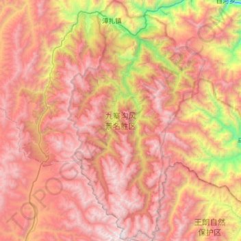
Nom : Carte topographique Jiuzhai Valley National Park, altitude, relief.
Altitude moyenne : 3 424 m
Altitude minimum : 1 554 m
Altitude maximum : 4 859 m
Autres cartes topographiques
Cliquez sur une carte pour visualiser sa topographie, son altitude et son relief.
Jiuzhaigou
China > Sichuan > Jiuzhaigou County
The county consists of nine villages in a valley in Sichuan Province. The main ethnic group in the county is Han, with the second being Tibetan. The county seat has an altitude of about 1,400 m (4,600 ft).[1] It has a total area of 2,041 square miles (5,286 km2).[2] As of 2015, the county's total population…
Altitude moyenne : 2 520 m