
Carte topographique Quien Sabe Glacier
Carte interactive
Cliquez sur la carte pour afficher l’altitude.
À propos de cette carte
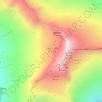
Nom : Carte topographique Quien Sabe Glacier, altitude, relief.
Altitude moyenne : 2 143 m
Altitude minimum : 1 555 m
Altitude maximum : 2 677 m
Autres cartes topographiques
Cliquez sur une carte pour visualiser sa topographie, son altitude et son relief.
Tukwila
USA > Washington > Tukwila
Tukwila, King County, Washington, 98188, USA
Altitude moyenne : 59 m
Olympic Mountains
Olympic Mountains, Jefferson County, Washington, 98305, USA
Altitude moyenne : 511 m
Challenger Glacier
Challenger Glacier, Little Beaver Trail, Whatcom County, Washington, USA
Altitude moyenne : 1 924 m
Douglas Glacier
Douglas Glacier, North Fork Bridge Creek, Chelan County, Washington, USA
Altitude moyenne : 2 038 m
Mount Rainier
Mount Rainier, Pierce County, Washington, USA
Altitude moyenne : 3 938 m
Forbidden Glacier
Forbidden Glacier, Sahale Arm Trail, Skagit County, Washington, USA
Altitude moyenne : 2 048 m
Kimtah Glacier
Kimtah Glacier, Fisher Creek Trail, Skagit County, Washington, USA
Altitude moyenne : 1 996 m
Inspiration Glacier
Inspiration Glacier, Roush basin access trail, Skagit County, Washington, USA
Altitude moyenne : 2 163 m
Chickamin Glacier
Chickamin Glacier, Ptarmigan Traverse, Chelan County, Washington, USA
Altitude moyenne : 2 124 m
Talum Glaciers
Talum Glaciers, Squak Glacier Route, Whatcom County, Washington, USA
Altitude moyenne : 2 118 m
Butterfly Glacier
Butterfly Glacier, Chelan County, Washington, USA
Altitude moyenne : 2 121 m
Neve Glacier
USA > Washington > Diablo
Neve Glacier, Pyramid Lake Trail, Diablo, Whatcom County, Washington, USA
Altitude moyenne : 2 074 m
Scimitar Glacier
Scimitar Glacier, Pacific Crest Trail, Snohomish County, Washington, USA
Altitude moyenne : 2 270 m
Chocolate Glacier
Chocolate Glacier, Pacific Crest Trail, Snohomish County, Washington, USA
Altitude moyenne : 2 469 m
Flett Glacier
Flett Glacier, Spray Park Trail, Pierce County, Washington, USA
Altitude moyenne : 2 185 m
Sandalee Glacier
Sandalee Glacier, McGregor Trail, Chelan County, Washington, USA
Altitude moyenne : 1 910 m
Edmunds Glacier
Edmunds Glacier, Pierce County, Washington, USA
Altitude moyenne : 2 619 m
Upper Curtis Glacier
Upper Curtis Glacier, Sulfide Glacier Route, Whatcom County, Washington, USA
Altitude moyenne : 2 059 m
Glacier Peak
Glacier Peak, Snohomish County, Washington, USA
Altitude moyenne : 2 653 m
Carrie Glacier
Carrie Glacier, Bailey Range Way Trail, Jefferson County, Washington, USA
Altitude moyenne : 1 725 m
Van Trump Glacier
USA > Washington > Paradise
Van Trump Glacier, Van Trump Trail, Paradise, Pierce County, Washington, USA
Altitude moyenne : 2 389 m
Wyeth Glacier
Wyeth Glacier, Park Creek Trail, Skagit County, Washington, USA
Altitude moyenne : 1 994 m
Stuart Glacier
Stuart Glacier, Horseshoe Lake Trail, Chelan County, Washington, USA
Altitude moyenne : 2 098 m
Dusty Glacier
Dusty Glacier, Pacific Crest Trail, Snohomish County, Washington, USA
Altitude moyenne : 2 371 m
Klawatti Glacier
Klawatti Glacier, Lucky ridge boot trail, Skagit County, Washington, USA
Altitude moyenne : 2 001 m
Opal Lake
Opal Lake, Necklace Valley Trail, King County, Washington, USA
Altitude moyenne : 1 677 m
Davenport Glacier
Davenport Glacier, Sahale Arm Trail, Skagit County, Washington, USA
Altitude moyenne : 2 143 m
North Cascades National Park
North Cascades National Park, Whatcom County, Washington, USA
Altitude moyenne : 1 151 m
Isella Glacier
USA > Washington > Holden Village
Isella Glacier, Cloudy Pass Trail #1256, Holden Village, Chelan County, Washington, USA
Altitude moyenne : 2 258 m
Cascade Range
Cascade Range, Skamania County, Washington, USA
Altitude moyenne : 690 m
Yawning Glacier
Yawning Glacier, Ptarmigan Traverse, Chelan County, Washington, USA
Altitude moyenne : 1 712 m
Boston Glacier
Boston Glacier, Sahale Arm Trail, Skagit County, Washington, USA
Altitude moyenne : 1 969 m
Katsuk Glacier
Katsuk Glacier, Fisher Creek Trail, Skagit County, Washington, USA
Altitude moyenne : 2 007 m
Dana Glacier
Dana Glacier, Ptarmigan Traverse, Chelan County, Washington, USA
Altitude moyenne : 2 003 m
Mount Shuksan
Mount Shuksan, Whatcom County, Washington, USA
Altitude moyenne : 2 126 m
Hadley Glacier
Hadley Glacier, Hadley Peak Route, Whatcom County, Washington, USA
Altitude moyenne : 1 815 m
Kennedy Glacier
Kennedy Glacier, Pacific Crest Trail, Snohomish County, Washington, USA
Altitude moyenne : 2 538 m
Goode Glacier
Goode Glacier, North Fork Bridge Creek, Chelan County, Washington, USA
Altitude moyenne : 1 877 m
Queets Glacier
Queets Glacier, Elwha Snowfinger Route, Jefferson County, Washington, USA
Altitude moyenne : 1 496 m
Sherpa Glacier
Sherpa Glacier, Horseshoe Lake Trail, Chelan County, Washington, USA
Altitude moyenne : 2 069 m
Cameron Glaciers
Cameron Glaciers, Main Fork Dosewallips River Trail, Jefferson County, Washington, USA
Altitude moyenne : 1 796 m
Fairchild Glacier
Fairchild Glacier, Mount Carrie Way Trail, Clallam County, Washington, USA
Altitude moyenne : 1 611 m
Whitman Glacier
Whitman Glacier, Wonderland Trail, Pierce County, Washington, USA
Altitude moyenne : 2 519 m
Carbon Glacier
Carbon Glacier, Wonderland Trail, Pierce County, Washington, USA
Altitude moyenne : 2 047 m
Ingraham Glacier
USA > Washington > Paradise
Ingraham Glacier, Camp Muir Route, Paradise, Pierce County, Washington, USA
Altitude moyenne : 2 489 m