
Carte topographique Avila Beach
Carte interactive
Cliquez sur la carte pour afficher l’altitude.
À propos de cette carte
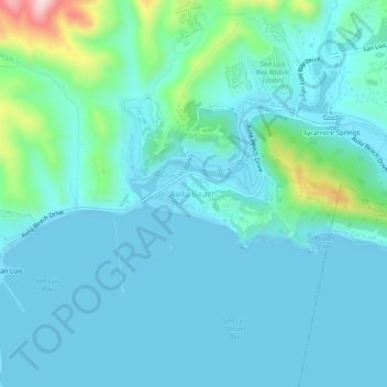
Nom : Carte topographique Avila Beach, altitude, relief.
Altitude moyenne : 46 m
Altitude minimum : -1 m
Altitude maximum : 316 m
The beach is less than 0.5 miles (0.8 km) long and sheltered in San Luis Bay, which is formed by Point San Luis on the west and Fossil Point on the east. Avila Beach faces south and the 600 foot elevation of Point San Luis breaks the prevailing northwesterly winds. It is therefore usually warmer than the other beaches on the Central Coast. Most of Avila Beach is undeveloped, except for a few blocks adjacent to the beach with homes, hotels, and small businesses, and a few upscale housing developments inland near a golf course. Avila Beach is also known for its hot springs, which are used for resort spas.
Autres cartes topographiques
Cliquez sur une carte pour visualiser sa topographie, son altitude et son relief.
San Luis Obispo
United States > California > San Luis Obispo County
San Luis Obispo, San Luis Obispo County, CAL Fire Southern Region, California, United States
Altitude moyenne : 133 m
Morro Bay
United States > California > San Luis Obispo County
Morro Bay, San Luis Obispo County, CAL Fire Southern Region, California, 93442, United States
Altitude moyenne : 54 m
Oceano
United States > California > San Luis Obispo County
Oceano, San Luis Obispo County, California, 93445, United States
Altitude moyenne : 16 m
Baywood Park
United States > California > San Luis Obispo County
Baywood Park, San Luis Obispo County, CAL Fire Southern Region, California, 93402, United States
Altitude moyenne : 21 m
Shandon
United States > California > San Luis Obispo County > Shandon
Shandon, San Luis Obispo County, CAL Fire Southern Region, California, 93461, United States
Altitude moyenne : 343 m
Morro Rock
United States > California > San Luis Obispo County > Morro Bay
Morro Rock, Morro Bay, San Luis Obispo County, CAL Fire Southern Region, California, 93442, United States
Altitude moyenne : 3 m
Bald Top
United States > California > San Luis Obispo County
Bald Top, San Luis Obispo County, CAL Fire Southern Region, California, United States
Altitude moyenne : 475 m
Nipomo
United States > California > San Luis Obispo County
Nipomo, San Luis Obispo County, California, 93444, United States
Altitude moyenne : 107 m
San Andreas Fault
United States > California > San Luis Obispo County
San Andreas Fault, San Luis Obispo County, California, United States
Altitude moyenne : 681 m
Creston
United States > California > San Luis Obispo County
Creston, San Luis Obispo County, CAL Fire Southern Region, California, United States
Altitude moyenne : 356 m
Heritage Ranch
United States > California > San Luis Obispo County
Heritage Ranch, San Luis Obispo County, CAL Fire Southern Region, California, United States
Altitude moyenne : 325 m
Caliente Mountain
United States > California > San Luis Obispo County
Caliente Mountain, San Luis Obispo County, CAL Fire Southern Region, California, United States
Altitude moyenne : 1 279 m
Templeton
United States > California > San Luis Obispo County
Templeton, San Luis Obispo County, CAL Fire Southern Region, California, 93465, United States
Altitude moyenne : 260 m
Santa Margarita
United States > California > San Luis Obispo County
Santa Margarita, San Luis Obispo County, CAL Fire Southern Region, California, United States
Altitude moyenne : 333 m
Mount Lowe
United States > California > San Luis Obispo County
Mount Lowe, San Luis Obispo County, CAL Fire Southern Region, California, United States
Altitude moyenne : 582 m
Cuesta-by-the-Sea
United States > California > San Luis Obispo County
Cuesta-by-the-Sea, San Luis Obispo County, CAL Fire Southern Region, California, 93402, United States
Altitude moyenne : 35 m
Pismo Beach
United States > California > San Luis Obispo County
Pismo Beach, San Luis Obispo County, CAL Fire Southern Region, California, 93449, United States
Altitude moyenne : 51 m
Oceano Beach
United States > California > San Luis Obispo County > Oceano
Oceano Beach, Oceano, San Luis Obispo County, CAL Fire Southern Region, California, 93445, United States
Altitude moyenne : 8 m
Cambria
United States > California > San Luis Obispo County
Cambria, San Luis Obispo County, California, United States
Altitude moyenne : 58 m
Grover Beach
United States > California > San Luis Obispo County > Grover Beach
Grover Beach, San Luis Obispo County, CAL Fire Southern Region, California, United States
Altitude moyenne : 21 m
Shell Beach
United States > California > San Luis Obispo County > Pismo Beach > Shell Beach
Shell Beach, Pismo Beach, San Luis Obispo County, California, 93449, United States
Altitude moyenne : 62 m
Arroyo Grande
United States > California > San Luis Obispo County > Arroyo Grande > Arroyo Grande
Arroyo Grande, San Luis Obispo County, California, 93420-2419, United States
Altitude moyenne : 56 m
Atascadero
United States > California > San Luis Obispo County
Atascadero, San Luis Obispo County, California, United States
Altitude moyenne : 337 m
Paso Robles
United States > California > San Luis Obispo County
Paso Robles, San Luis Obispo County, CAL Fire Southern Region, California, 93447, United States
Altitude moyenne : 298 m
Arroyo Grande
United States > California > San Luis Obispo County
Arroyo Grande, San Luis Obispo County, CAL Fire Southern Region, California, United States
Altitude moyenne : 52 m
San Simeon
United States > California > San Luis Obispo County
San Simeon, San Luis Obispo County, CAL Fire Southern Region, California, 93452, United States
Altitude moyenne : 31 m
Cayucos
United States > California > San Luis Obispo County
Cayucos, San Luis Obispo County, California, 93430, United States
Altitude moyenne : 47 m