
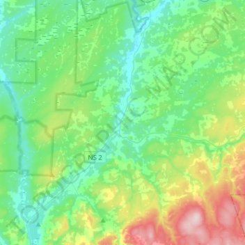
Carte topographique Southampton
Carte interactive
Cliquez sur la carte pour afficher l’altitude.
À propos de cette carte
Nom : Carte topographique Southampton, altitude, relief.
Altitude moyenne : 78 m
Altitude minimum : 3 m
Altitude maximum : 294 m
Autres cartes topographiques
Cliquez sur une carte pour visualiser sa topographie, son altitude et son relief.
Hastings
Canada > Nova Scotia > Municipality of the County of Cumberland
Hastings, Municipality of the County of Cumberland, Cumberland County, Nova Scotia, B4H 3Y3, Canada
Altitude moyenne : 63 m
Brookdale
Canada > Nova Scotia > Municipality of the County of Cumberland
Brookdale, Municipality of the County of Cumberland, Cumberland County, Nova Scotia, B4H 3Y3, Canada
Altitude moyenne : 52 m
Hansford
Canada > Nova Scotia > Municipality of the County of Cumberland
Hansford, Municipality of the County of Cumberland, Cumberland County, Nova Scotia, B0M 1P0, Canada
Altitude moyenne : 54 m
Port Philip
Canada > Nova Scotia > Municipality of the County of Cumberland
Port Philip, Municipality of the County of Cumberland, Cumberland County, Nova Scotia, B0K 1L0, Canada
Altitude moyenne : 12 m
Muddy Plains
Canada > Nova Scotia > Municipality of the County of Cumberland > Shulie
Muddy Plains, Shulie, Municipality of the County of Cumberland, Cumberland County, Nova Scotia, B0L 1A0, Canada
Altitude moyenne : 125 m