
Carte topographique Daegwannyeong-myeon
Carte interactive
Cliquez sur la carte pour afficher l’altitude.
À propos de cette carte
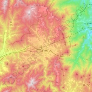
Nom : Carte topographique Daegwannyeong-myeon, altitude, relief.
Lieu : Daegwannyeong-myeon, Pyeongchang-gun, Gangwon, South Korea (37.58843 128.59000 37.78246 128.76511)
Altitude moyenne : 772 m
Altitude minimum : 55 m
Altitude maximum : 1 443 m
Autres cartes topographiques
Cliquez sur une carte pour visualiser sa topographie, son altitude et son relief.
Jangpyeong-ri
South Korea > Pyeongchang-gun > Yongpyeong-myeon
Jangpyeong-ri, Yongpyeong-myeon, Pyeongchang-gun, Gangwon State, 25315, South Korea
Altitude moyenne : 609 m
Hoedong-ri
South Korea > Pyeongchang-gun > Mitan-myeon
Hoedong-ri, Mitan-myeon, Pyeongchang-gun, Gangwon State, 25380, South Korea
Altitude moyenne : 710 m
Gyebangsan
South Korea > Pyeongchang-gun > Yongpyeong-myeon
Gyebangsan, Yongpyeong-myeon, Pyeongchang-gun, Gangwon State, South Korea
Altitude moyenne : 1 252 m
Yongsan-ri
South Korea > Pyeongchang-gun > Daegwannyeong-myeon
Yongsan-ri, Daegwannyeong-myeon, Pyeongchang-gun, Gangwon, 25351, South Korea
Altitude moyenne : 851 m
발왕산
South Korea > Pyeongchang-gun > Daegwannyeong-myeon
발왕산, Daegwannyeong-myeon, Pyeongchang-gun, Gangwon, 25352, South Korea
Altitude moyenne : 1 137 m
Pyeongchang-eup
South Korea > Pyeongchang-gun > Pyeongchang-eup
Pyeongchang-eup, Pyeongchang-gun, Gangwon, 25375, South Korea
Altitude moyenne : 454 m