
Carte topographique The Foss
Carte interactive
Cliquez sur la carte pour afficher l’altitude.
À propos de cette carte
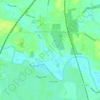
Nom : Carte topographique The Foss, altitude, relief.
Altitude moyenne : 9 m
Altitude minimum : 3 m
Altitude maximum : 17 m
Autres cartes topographiques
Cliquez sur une carte pour visualiser sa topographie, son altitude et son relief.
The Foss
United Kingdom > England > Selby
The Foss, Selby, North Yorkshire, Yorkshire and the Humber, England, LS24 8ED, United Kingdom
Altitude moyenne : 13 m
Adaman Graves
United Kingdom > England > Selby
Adaman Graves, Selby, North Yorkshire, Yorkshire and the Humber, England, LS24 9LY, United Kingdom
Altitude moyenne : 20 m