
Carte topographique Glan-Münchweiler
Carte interactive
Cliquez sur la carte pour afficher l’altitude.
À propos de cette carte
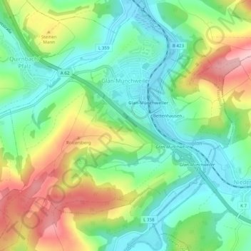
Nom : Carte topographique Glan-Münchweiler, altitude, relief.
Altitude moyenne : 277 m
Altitude minimum : 210 m
Altitude maximum : 392 m
Autres cartes topographiques
Cliquez sur une carte pour visualiser sa topographie, son altitude et son relief.
Wolfstein
Duitsland > Rijnland-Palts > Landkreis Kusel
Wolfstein, Lauterecken-Wolfstein, Landkreis Kusel, Rijnland-Palts, 67752, Duitsland
Altitude moyenne : 327 m
Ohmbach
Duitsland > Rijnland-Palts > Landkreis Kusel
Ohmbach, Oberes Glantal, Landkreis Kusel, Rijnland-Palts, Duitsland
Altitude moyenne : 311 m
Bosenbach
Duitsland > Rijnland-Palts > Landkreis Kusel > Bosenbach
Bosenbach, Kusel-Altenglan, Landkreis Kusel, Rijnland-Palts, Duitsland
Altitude moyenne : 348 m