
Carte topographique Snake Range
Carte interactive
Cliquez sur la carte pour afficher l’altitude.
À propos de cette carte
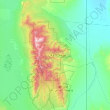
Nom : Carte topographique Snake Range, altitude, relief.
Altitude moyenne : 1 984 m
Altitude minimum : 1 503 m
Altitude maximum : 3 957 m
Autres cartes topographiques
Cliquez sur une carte pour visualiser sa topographie, son altitude et son relief.
Wheeler Peak Glacier
Wheeler Peak Glacier, Bristlecone and Glacier Trail, White Pine County, Nevada, USA
Altitude moyenne : 3 500 m
Whistler Mountain
Whistler Mountain, Eureka County, Nevada, USA
Altitude moyenne : 2 211 m
Red Rock Canyon National Conservation Area
USA > Nevada > Mountain Springs
Red Rock Canyon National Conservation Area, NV 160, Mountain Springs, Clark County, Nevada, USA
Altitude moyenne : 1 361 m
North Las Vegas
USA > Nevada > North Las Vegas
North Las Vegas, Clark County, Nevada, USA
Altitude moyenne : 682 m
Jeff Davis Peak
Jeff Davis Peak, White Pine County, Nevada, USA
Altitude moyenne : 3 432 m
River Mountains Loop Trail
USA > Nevada > Boulder City
River Mountains Loop Trail, Boulder City, Clark County, Nevada, 89005, USA
Altitude moyenne : 756 m