
Carte topographique Balabac Island
Carte interactive
Cliquez sur la carte pour afficher l’altitude.
À propos de cette carte
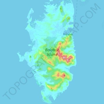
Nom : Carte topographique Balabac Island, altitude, relief.
Lieu : Balabac Island, Palawan, Mimaropa, Philippines (7.80361 116.92920 8.07515 117.08658)
Altitude moyenne : 20 m
Altitude minimum : 0 m
Altitude maximum : 531 m
Autres cartes topographiques
Cliquez sur une carte pour visualiser sa topographie, son altitude et son relief.
Long Beach
Philippines > Palawan > Roxas
Long Beach, Roxas, Palawan, Mimaropa, Philippines
Altitude moyenne : 17 m
Maducang Island
Maducang Island, Palawan, Mimaropa, Philippines
Altitude moyenne : 31 m
Busuanga Island
Busuanga Island, Coron, Palawan, Mimaropa, 5316, Philippines
Altitude moyenne : 33 m