
Carte topographique South Oxfordshire
Carte interactive
Cliquez sur la carte pour afficher l’altitude.
À propos de cette carte
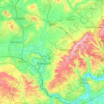
Nom : Carte topographique South Oxfordshire, altitude, relief.
Altitude moyenne : 97 m
Altitude minimum : 28 m
Altitude maximum : 261 m
Autres cartes topographiques
Cliquez sur une carte pour visualiser sa topographie, son altitude et son relief.
Didcot
United Kingdom > England > South Oxfordshire > Didcot
Didcot, South Oxfordshire, Oxfordshire, South East, England, OX11 8QZ, United Kingdom
Altitude moyenne : 68 m
Chinnor
United Kingdom > England > South Oxfordshire > Chinnor
Chinnor, South Oxfordshire, Oxfordshire, South East, England, OX39 4PZ, United Kingdom
Altitude moyenne : 133 m
Holton
United Kingdom > England > South Oxfordshire > Holton
Holton, South Oxfordshire, Oxfordshire, South East, England, United Kingdom
Altitude moyenne : 74 m