
Carte topographique Durg
Carte interactive
Cliquez sur la carte pour afficher l’altitude.
À propos de cette carte
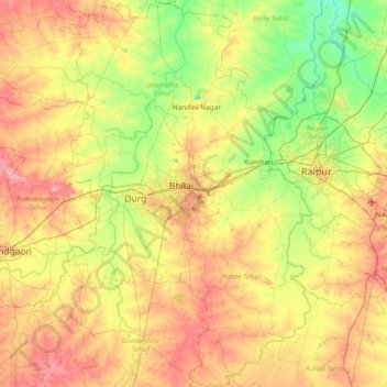
Nom : Carte topographique Durg, altitude, relief.
Lieu : Durg, Chhattisgarh, India (20.85031 81.14466 21.54485 81.62513)
Altitude moyenne : 295 m
Altitude minimum : 255 m
Altitude maximum : 347 m
Autres cartes topographiques
Cliquez sur une carte pour visualiser sa topographie, son altitude et son relief.
Nava Raipur
India > Chhattisgarh > Arang Tahsil
Nava Raipur, Arang Tahsil, Raipur District, Chhattisgarh, India
Altitude moyenne : 305 m
Pendri
India > Chhattisgarh > Rajnandgaon Tahsil
Pendri, Rajnandgaon Tahsil, Rajnandgaon District, Chhattisgarh, 491441, India
Altitude moyenne : 309 m
Kharsia Tahsil
Kharsia Tahsil, Raigarh District, Chhattisgarh, India
Altitude moyenne : 270 m
Sarangarh
India > Chhattisgarh > Sarangarh Tahsil
Sarangarh, Sarangarh Tahsil, Sarangarh-Bilaigarh District, Chhattisgarh, India
Altitude moyenne : 236 m
Pratappur Tahsil
Pratappur Tahsil, Surajpur District, Chhattisgarh, India
Altitude moyenne : 536 m
Sonhat
India > Chhattisgarh > Sonhat Tahsil
Sonhat, Sonhat Tahsil, Koriya District, Chhattisgarh, 497346, India
Altitude moyenne : 756 m
Kawardha
India > Chhattisgarh > Kawardha Tahsil
Kawardha, Kawardha Tahsil, Kabirdham District, Chhattisgarh, 491995, India
Altitude moyenne : 350 m
Janjgir
India > Chhattisgarh > Janjgir Tahsil
Janjgir, Janjgir Tahsil, Janjgir-Champa District, Chhattisgarh, 495668, India
Altitude moyenne : 265 m
Baloda Bazar Tahsil
Baloda Bazar Tahsil, Baloda Bazar District, Chhattisgarh, India
Altitude moyenne : 255 m
Ramanuj Ganj
India > Chhattisgarh > Ramanujganj Tahsil
Ramanuj Ganj, Ramanujganj Tahsil, Balrampur District, Chhattisgarh, India
Altitude moyenne : 438 m
Sukma
India > Chhattisgarh > Sukma Tahsil
Sukma, Sukma Tahsil, Sukma District, Chhattisgarh, 494111, India
Altitude moyenne : 219 m
Magarlod
India > Chhattisgarh > Magarlod Tahsil
Magarlod, Magarlod Tahsil, Dhamtari District, Chhattisgarh, 493662, India
Altitude moyenne : 314 m
Abhanpur Tahsil
Abhanpur Tahsil, Raipur District, Chhattisgarh, India
Altitude moyenne : 294 m
Balodabazar
India > Chhattisgarh > Baloda Bazar Tahsil
Balodabazar, Baloda Bazar Tahsil, Baloda Bazar District, Chhattisgarh, 495559, India
Altitude moyenne : 246 m
Dhamtari Tahsil
Dhamtari Tahsil, Dhamtari District, Chhattisgarh, India
Altitude moyenne : 341 m
Digi
India > Chhattisgarh > Tamnar Tahsil
Digi, Tamnar Tahsil, Raigarh District, Chhattisgarh, India
Altitude moyenne : 255 m
Rajnandgaon
India > Chhattisgarh > Rajnandgaon Tahsil
Rajnandgaon, Rajnandgaon Tahsil, Rajnandgaon, Chhattisgarh, 491441, India
Altitude moyenne : 309 m
Devgaon
India > Chhattisgarh > Malkharoda Tahsil
Devgaon, Malkharoda Tahsil, Sakti, Chhattisgarh, India
Altitude moyenne : 211 m
Dongargarh
India > Chhattisgarh > Dongargarh Tahsil
Dongargarh, Dongargarh Tahsil, Rajnandgaon District, Chhattisgarh, 491445, India
Altitude moyenne : 356 m
Raipur
India > Chhattisgarh > Raipur Tahsil
Raipur, Raipur Tahsil, Raipur District, Chhattisgarh, 493332, India
Altitude moyenne : 288 m
Durg
India > Chhattisgarh > Durg Tahsil
Durg, Durg Tahsil, Durg District, Chhattisgarh, 491002, India
Altitude moyenne : 295 m
Pali Tahsil
India > Chhattisgarh > Pali Tahsil
Pali Tahsil, Korba District, Chhattisgarh, India
Altitude moyenne : 416 m
Raigarh Tahsil
India > Chhattisgarh > Raigarh Tahsil
Raigarh Tahsil, Raigarh District, Chhattisgarh, India
Altitude moyenne : 256 m
Bhilai
India > Chhattisgarh > Durg Tahsil
Bhilai, Durg Tahsil, Durg District, Chhattisgarh, 490023, India
Altitude moyenne : 292 m
Bilha Tahsil
Bilha Tahsil, Bilaspur, Chhattisgarh, 495224, India
Altitude moyenne : 255 m
Korba
India > Chhattisgarh > Korba Tahsil > Korba
Korba, Korba Tahsil, Korba, Chhattisgarh, 495600, India
Altitude moyenne : 322 m
Ambikapur
India > Chhattisgarh > Ambikapur
Ambikapur, Ambikapur Tahsil, Surguja, Chhattisgarh, 497001, India
Altitude moyenne : 605 m
Raipur
India > Chhattisgarh > Raipur
Raipur, Raipur Tahsil, Raipur, Chhattisgarh, 493332, India
Altitude moyenne : 288 m