
Carte topographique Chauk Township
Carte interactive
Cliquez sur la carte pour afficher l’altitude.
À propos de cette carte
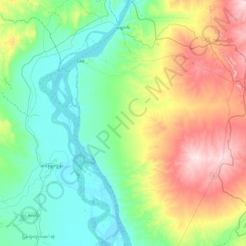
Nom : Carte topographique Chauk Township, altitude, relief.
Lieu : Chauk Township, Magway District, Magway, 24398, Myanmar (20.52672 94.68455 20.94052 95.04219)
Altitude moyenne : 156 m
Altitude minimum : 38 m
Altitude maximum : 419 m
Autres cartes topographiques
Cliquez sur une carte pour visualiser sa topographie, son altitude et son relief.
Pindale
Myanmar > Magway > Seikphyu Township
Pindale, Seikphyu Township, Pakokku District, Magway, Myanmar
Altitude moyenne : 81 m
Swedon
Myanmar > Magway > Aunglan Township
Swedon, Aunglan Township, Thayet District, Magway, Myanmar
Altitude moyenne : 166 m
Seikphyu Township
Seikphyu Township, Pakokku District, Magway, Myanmar
Altitude moyenne : 166 m
Aunglan Township
Myanmar > Magway > Thayet District > Aunglan Township
Aunglan Township, Thayet District, Magway, 04151, Myanmar
Altitude moyenne : 115 m
Thanat
Myanmar > Magway > Thayet District > Aunglan Township > Thanat
Thanat, Aunglan Township, Thayet District, Magway, Myanmar
Altitude moyenne : 104 m
Mindon Township
Myanmar > Magway > Thayet District > Mindon Township
Mindon Township, Thayet District, Magway, Myanmar
Altitude moyenne : 335 m
Minbu District
Myanmar > Magway > Minbu District
Minbu District, Magway, Myanmar
Altitude moyenne : 327 m
Saw Township
Myanmar > Magway > Saw Township
Saw Township, Gangaw District, Magway, Myanmar
Altitude moyenne : 762 m
Irrawaddy River
Irrawaddy River, Magway District, Magway, 08151, Myanmar
Altitude moyenne : 438 m