
Carte topographique Yerupajá
Carte interactive
Cliquez sur la carte pour afficher l’altitude.
À propos de cette carte
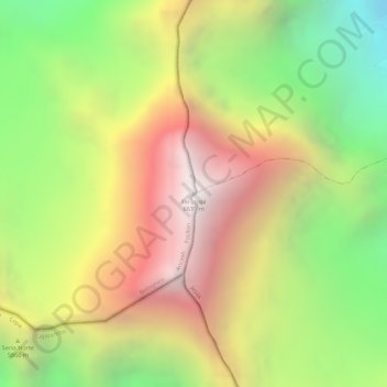
Nom : Carte topographique Yerupajá, altitude, relief.
Lieu : Yerupajá, Pacllón, Province of Bolognesi, Ancash, Peru (-10.26867 -76.90561 -10.26857 -76.90551)
Altitude moyenne : 5 637 m
Altitude minimum : 4 698 m
Altitude maximum : 6 506 m
Based on the elevation provided by the available Digital elevation models, SRTM2 (6558m with voids), SRTM filled with ASTER (6551m with voids), TanDEM-X(6110m with voids), Yerupaja is about 6635 meters above sea level. This altitude was considered due to the lack of topographic data or even handheld GPS data.