
Merci de soutenir ce site ❤️
Faire un don
Faire un don
Équipez-vous pour votre prochaine aventure :
En tant que Partenaire Amazon, ce site perçoit une commission sur les achats éligibles sans surcoût pour vous.
Carte topographique Abohar
Cliquez sur la carte pour afficher l’altitude.
Merci de soutenir ce site ❤️
Faire un don
Faire un don
Équipez-vous pour votre prochaine aventure :
🧭Boussole de randonnée - Boussole de haute précision avec inclinomètre pour lecture de cartes topographiques
En tant que Partenaire Amazon, ce site perçoit une commission sur les achats éligibles sans surcoût pour vous.
À propos de cette carte
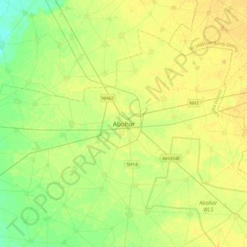
Nom : Carte topographique Abohar, altitude, relief.
Lieu : Abohar, Abohar Tahsil, Fazilka District, Punjab, 152116, India (29.98505 74.03566 30.30505 74.35566)
Altitude moyenne : 188 m
Altitude minimum : 177 m
Altitude maximum : 195 m
Merci de soutenir ce site ❤️
Faire un don
Faire un don
Équipez-vous pour votre prochaine aventure :
En tant que Partenaire Amazon, ce site perçoit une commission sur les achats éligibles sans surcoût pour vous.