
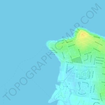
Carte topographique Gatakers Bay Foreshore Reserve
Carte interactive
Cliquez sur la carte pour afficher l’altitude.
À propos de cette carte
Nom : Carte topographique Gatakers Bay Foreshore Reserve, altitude, relief.
Altitude moyenne : 3 m
Altitude minimum : -5 m
Altitude maximum : 26 m
Autres cartes topographiques
Cliquez sur une carte pour visualiser sa topographie, son altitude et son relief.
Dundowran
Australia > Queensland > Hervey Bay
Dundowran, Hervey Bay, Fraser Coast Regional, Queensland, Australia
Altitude moyenne : 15 m
Eli Waters
Australia > Queensland > Hervey Bay
Eli Waters, Hervey Bay, Fraser Coast Regional, Queensland, Australia
Altitude moyenne : 3 m
Big Woody Island
Australia > Queensland > Hervey Bay
Big Woody Island, Great Sandy Strait, Hervey Bay, Fraser Coast Regional, Queensland, Australia
Altitude moyenne : 3 m
Dundowran beach
Australia > Queensland > Hervey Bay > Dundowran Beach
Dundowran beach, Dundowran Beach, Hervey Bay, Fraser Coast Regional, Queensland, Australia
Altitude moyenne : 4 m
Craignish
Australia > Queensland > Hervey Bay > Craignish
Craignish, Hervey Bay, Queensland, Australia
Altitude moyenne : 8 m
Quota Park
Australia > Queensland > Hervey Bay
Quota Park, Urangan, Hervey Bay, Queensland, Australia
Altitude moyenne : 3 m
Wanggoolba Creek
Australia > Queensland > Hervey Bay
Wanggoolba Creek, Hervey Bay, Queensland, Australia
Altitude moyenne : 49 m