
Carte topographique Monza
Carte interactive
Cliquez sur la carte pour afficher l’altitude.
À propos de cette carte
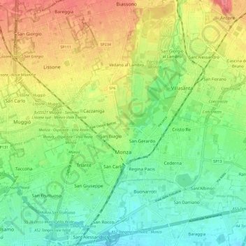
Nom : Carte topographique Monza, altitude, relief.
Lieu : Monza, Monza and Brianza, Lombardy, 20900, Italy (45.55326 9.22703 45.63220 9.32439)
Altitude moyenne : 175 m
Altitude minimum : 145 m
Altitude maximum : 217 m
Monza is located in the high plains of Lombardy, between Brianza and Milan, at an altitude of 162 metres (531 feet) above sea level. It is 15 kilometres (9 mi) from the centre of the region's capital, although when considering the cities borders, they are separated by less than 5 km (3 miles). Monza is about 40 km (25 mi) from Lecco and Como. Monza shares its position with Milan in the same metro area, and is a big part of its new province.