
Carte topographique Hayden Glacier
Carte interactive
Cliquez sur la carte pour afficher l’altitude.
À propos de cette carte
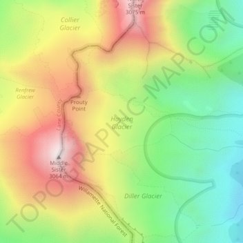
Nom : Carte topographique Hayden Glacier, altitude, relief.
Altitude moyenne : 2 542 m
Altitude minimum : 2 119 m
Altitude maximum : 3 046 m
Autres cartes topographiques
Cliquez sur une carte pour visualiser sa topographie, son altitude et son relief.
Crater Lake National Park
USA > Oregon > Rim Village
Crater Lake National Park, Summit Trail, Rim Village, Klamath County, Oregon, 97604, USA
Altitude moyenne : 1 726 m
Renfrew Glacier
Renfrew Glacier, climber's trail, Deschutes County, Oregon, USA
Altitude moyenne : 2 538 m
Diller Glacier
Diller Glacier, climber's trail, Deschutes County, Oregon, USA
Altitude moyenne : 2 416 m
Linn Glacier
Linn Glacier, Pacific Crest Trail, Deschutes County, Oregon, USA
Altitude moyenne : 2 359 m
Prouty Glacier
Prouty Glacier, South Sister Climber Trail #36, Deschutes County, Oregon, USA
Altitude moyenne : 2 589 m
Reid Glacier
Reid Glacier, Yocum Ridge Trail #771, Clackamas County, Oregon, USA
Altitude moyenne : 2 410 m
Glisan Glacier
Glisan Glacier, McNeil Point Trail #600M, Hood River County, Oregon, USA
Altitude moyenne : 2 086 m
Sandy Glacier
Sandy Glacier, Yocum Ridge Trail #771, Clackamas County, Oregon, USA
Altitude moyenne : 2 365 m
Skinner Glacier
Skinner Glacier, South Sister Climber Trail #36, Deschutes County, Oregon, USA
Altitude moyenne : 2 480 m
Bend Glacier
Bend Glacier, Broken Top NW Ridge route, Deschutes County, Oregon, USA
Altitude moyenne : 2 350 m
Milk Creek Glacier
Milk Creek Glacier, Pacific Crest Trail, Jefferson County, Oregon, USA
Altitude moyenne : 2 508 m
Wallowa Mountains
Wallowa Mountains, Wallowa County, Oregon, USA
Altitude moyenne : 2 475 m
Three Fingered Jack
Three Fingered Jack, Linn County, Oregon, USA
Altitude moyenne : 1 881 m
Ladd Glacier
Ladd Glacier, Barrett Spur, Hood River County, Oregon, USA
Altitude moyenne : 2 305 m
Coe Glacier
Coe Glacier, Barrett Spur, Hood River County, Oregon, USA
Altitude moyenne : 2 328 m
Newton Clark Glacier
Newton Clark Glacier, Cooper Spur Trail #600B, Hood River County, Oregon, USA
Altitude moyenne : 2 589 m
Carver Glacier
Carver Glacier, South Sister Climber Trail #36, Deschutes County, Oregon, USA
Altitude moyenne : 2 385 m
Zigzag Glacier
Zigzag Glacier, Mountaineer Trail #798, Clackamas County, Oregon, USA
Altitude moyenne : 2 620 m
Whitewater Glacier
Whitewater Glacier, Pacific Crest Trail, Jefferson County, Oregon, USA
Altitude moyenne : 2 460 m
Benson Glacier
Benson Glacier, Eagle Cap Summit Trail, Union County, Oregon, USA
Altitude moyenne : 2 489 m
Mount Tabor
Mount Tabor, Portland, Multnomah County, Oregon, 97215, USA
Altitude moyenne : 86 m
Hosford-Abernethy
Hosford-Abernethy, Portland, Multnomah County, Oregon, USA
Altitude moyenne : 26 m
Coalman Glacier
Coalman Glacier, Cooper Spur Trail #600B, Hood River County, Oregon, USA
Altitude moyenne : 2 728 m
Waldo Glacier
Waldo Glacier, Pacific Crest Trail, Jefferson County, Oregon, USA
Altitude moyenne : 2 352 m
Langille Glacier
Langille Glacier, Eliot west moraine, Hood River County, Oregon, USA
Altitude moyenne : 2 165 m
Clark Glacier
Clark Glacier, South Sister Climber Trail #36, Deschutes County, Oregon, USA
Altitude moyenne : 2 578 m
Lost Creek Glacier
Lost Creek Glacier, South Sister Climber Trail #36, Deschutes County, Oregon, USA
Altitude moyenne : 2 430 m
Cove Orchard
USA > Oregon > Cove Orchard
Cove Orchard, Yamhill County, Oregon, 97148, USA
Altitude moyenne : 126 m
Lathrop Glacier
Lathrop Glacier, Mt. Thielsen climber's trail, Douglas County, Oregon, USA
Altitude moyenne : 2 235 m
Thayer Glacier
Thayer Glacier, climber's trail, Deschutes County, Oregon, USA
Altitude moyenne : 2 423 m