
Carte topographique Gallarate
Carte interactive
Cliquez sur la carte pour afficher l’altitude.
À propos de cette carte
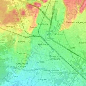
Nom : Carte topographique Gallarate, altitude, relief.
Lieu : Gallarate, Varese, Lombardy, 21013, Italy (45.63119 8.75368 45.69043 8.83244)
Altitude moyenne : 254 m
Altitude minimum : 222 m
Altitude maximum : 309 m
Founded by the Gauls and later conquered by the Romans, Gallarate was mentioned as an important vicus or village in documents dating back to the Roman conquest of what was then called Gallia Cisalpina. After the Carolingian conquest of northern-central Italy, a castle was erected upon the remains of the original Roman fortifications located beside the still existing Basilica of Santa Maria. The castle has disappeared, but its ancient location is identified through the city's topography and by the street name Via Postcastello.