
Carte topographique Broadford
Carte interactive
Cliquez sur la carte pour afficher l’altitude.
À propos de cette carte
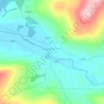
Nom : Carte topographique Broadford, altitude, relief.
Altitude moyenne : 95 m
Altitude minimum : 21 m
Altitude maximum : 276 m
Autres cartes topographiques
Cliquez sur une carte pour visualiser sa topographie, son altitude et son relief.
Saint Catherines
Saint Catherines, Boherglass ED, Killaloe Municipal District, County Clare, Munster, Ireland
Altitude moyenne : 91 m
Cliffs of Moher
Cliffs of Moher, Ballysteen ED, West Clare Municipal District, County Clare, Munster, Ireland
Altitude moyenne : 55 m
West Clare Municipal District
West Clare Municipal District, County Clare, Munster, Ireland
Altitude moyenne : 37 m
Elmvale
Elmvale, Killinaboy ED, West Clare Municipal District, County Clare, Munster, Ireland
Altitude moyenne : 53 m
Ardnacrusha
Ardnacrusha, Ballyglass ED, Shannon Municipal District, County Clare, Munster, V94 HXW5, Ireland
Altitude moyenne : 39 m