
Carte topographique Setting Lake
Cliquez sur la carte pour afficher l’altitude.
À propos de cette carte
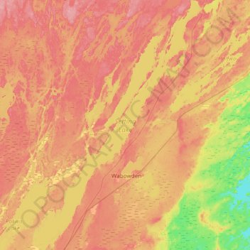
Nom : Carte topographique Setting Lake, altitude, relief.
Altitude moyenne : 229 m
Altitude minimum : 184 m
Altitude maximum : 260 m
Autres cartes topographiques
Cliquez sur une carte pour visualiser sa topographie, son altitude et son relief.
Paint Lake Provincial Park
Canada > Manitoba > Local Government District of Mystery Lake
Altitude moyenne : 198 m