
Faire un don
Équipez-vous pour votre prochaine aventure :
En tant que Partenaire Amazon, ce site perçoit une commission sur les achats éligibles sans surcoût pour vous.
Carte topographique Inglewood
Cliquez sur la carte pour afficher l’altitude.
Faire un don
Équipez-vous pour votre prochaine aventure :
En tant que Partenaire Amazon, ce site perçoit une commission sur les achats éligibles sans surcoût pour vous.
À propos de cette carte
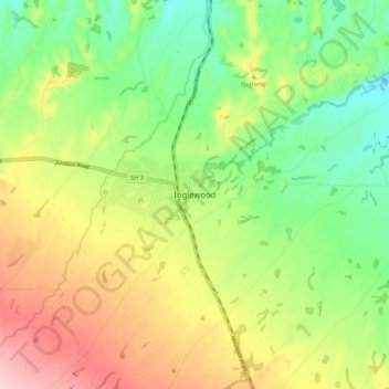
Nom : Carte topographique Inglewood, altitude, relief.
Altitude moyenne : 208 m
Altitude minimum : 123 m
Altitude maximum : 323 m
Faire un don
Équipez-vous pour votre prochaine aventure :
En tant que Partenaire Amazon, ce site perçoit une commission sur les achats éligibles sans surcoût pour vous.
Autres cartes topographiques
Cliquez sur une carte pour visualiser sa topographie, son altitude et son relief.
Te Papa-Kura-o-Taranaki
New Zealand > Taranaki > New Plymouth District
The park is located on the west coast of the North Island and is exposed to prevailing winds from the west or northwest. Moist westerlies from the Tasman Sea create orographic precipitation when they reach Mount Taranaki and the adjacent Pouākai and Kaitake ranges. Southerly winds are also common. The…
Altitude moyenne : 500 m