
Carte topographique Ward 24
Carte interactive
Cliquez sur la carte pour afficher l’altitude.
À propos de cette carte
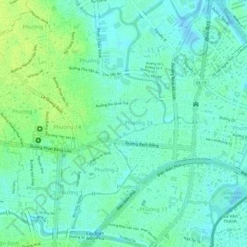
Nom : Carte topographique Ward 24, altitude, relief.
Lieu : Ward 24, Binh Thanh District, 720000, Vietnam (10.80283 106.69872 10.80823 106.71151)
Altitude moyenne : 7 m
Altitude minimum : -2 m
Altitude maximum : 15 m
Autres cartes topographiques
Cliquez sur une carte pour visualiser sa topographie, son altitude et son relief.
Thanh Da Peninsula
Thanh Da Peninsula, Binh Thanh District, Ho Chi Minh City, 717402, Vietnam
Altitude moyenne : 3 m