
Carte topographique Oberthal
Carte interactive
Cliquez sur la carte pour afficher l’altitude.
À propos de cette carte
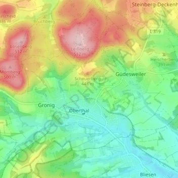
Nom : Carte topographique Oberthal, altitude, relief.
Lieu : Oberthal, Landkreis St. Wendel, Saarland, 66649, Deutschland (49.49410 7.05815 49.53968 7.12050)
Altitude moyenne : 377 m
Altitude minimum : 289 m
Altitude maximum : 520 m
Autres cartes topographiques
Cliquez sur une carte pour visualiser sa topographie, son altitude et son relief.
Güdesweiler
Deutschland > Saarland > Oberthal
Güdesweiler, Oberthal, Landkreis St. Wendel, Saarland, Deutschland
Altitude moyenne : 380 m
Momberg
Deutschland > Saarland > Oberthal
Momberg, Oberthal, Landkreis St. Wendel, Saarland, 66649, Deutschland
Altitude moyenne : 410 m