
Carte topographique Bản Dơ Tơ Bo
Carte interactive
Cliquez sur la carte pour afficher l’altitude.
À propos de cette carte
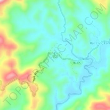
Nom : Carte topographique Bản Dơ Tơ Bo, altitude, relief.
Lieu : Bản Dơ Tơ Bo, Lạc Dương District, Lâm Đồng Province, Vietnam (12.11919 108.61356 12.15919 108.65356)
Altitude moyenne : 1 506 m
Altitude minimum : 1 404 m
Altitude maximum : 1 772 m
Autres cartes topographiques
Cliquez sur une carte pour visualiser sa topographie, son altitude et son relief.
Mont Lang Biang belvédère
Vietnam > Lâm Đồng Province > Lạc Dương District > Lạc Dương
Mont Lang Biang belvédère, Lạc Dương, Lạc Dương District, Lâm Đồng Province, Vietnam
Altitude moyenne : 1 620 m