
Faire un don
Équipez-vous pour votre prochaine aventure :
En tant que Partenaire Amazon, ce site perçoit une commission sur les achats éligibles sans surcoût pour vous.
Carte topographique Long Nawang
Cliquez sur la carte pour afficher l’altitude.
Faire un don
Équipez-vous pour votre prochaine aventure :
En tant que Partenaire Amazon, ce site perçoit une commission sur les achats éligibles sans surcoût pour vous.
À propos de cette carte
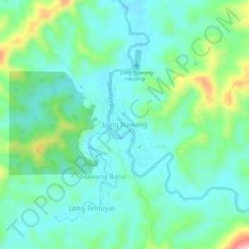
Nom : Carte topographique Long Nawang, altitude, relief.
Lieu : Long Nawang, North Kalimantan, Kalimantan, Indonesia (1.76935 114.88230 1.80935 114.92230)
Altitude moyenne : 627 m
Altitude minimum : 574 m
Altitude maximum : 791 m
Faire un don
Équipez-vous pour votre prochaine aventure :
En tant que Partenaire Amazon, ce site perçoit une commission sur les achats éligibles sans surcoût pour vous.
Autres cartes topographiques
Cliquez sur une carte pour visualiser sa topographie, son altitude et son relief.
Faire un don
Équipez-vous pour votre prochaine aventure :
En tant que Partenaire Amazon, ce site perçoit une commission sur les achats éligibles sans surcoût pour vous.
Malinau
Malinau borders Nunukan Regency in the north, Tana Tidung, Bulungan, and Berau regencies in the east, East Kutai, Kutai Kartanegara, and West Kutai regencies in the south, and the Malaysian state of Sabah in the west. From its 40,088.38 square kilometers of area, Kayan Mentarang National Park consist of 24.88%…
Altitude moyenne : 627 m