
Faire un don
Équipez-vous pour votre prochaine aventure :
En tant que Partenaire Amazon, ce site perçoit une commission sur les achats éligibles sans surcoût pour vous.
Carte topographique Rwenzori Mountains
Cliquez sur la carte pour afficher l’altitude.
Faire un don
Équipez-vous pour votre prochaine aventure :
En tant que Partenaire Amazon, ce site perçoit une commission sur les achats éligibles sans surcoût pour vous.
Rwenzori Mountains
There is no water shortage in the Ruwenzori; yet, several members of the afro-alpine family resemble species that normally thrive in desert climates. The reason lies in their similar water economy. Water is not always readily available to the afroalpine plants when they need it. In addition, nightly frosts affect the sap transport in the plants and the intake of water by its roots. As the day begins, the air temperature and radiation level rise rapidly, putting strenuous demands on the exposed parts of the plants as they try to meet the transpiration demands of the leaves and maintain a proper water balance. To counter the effects of freezing, the afro-alpine plants have developed the insulation systems that give them such a striking appearance. These adaptations become more prominent as the elevation increases.
Faire un don
Équipez-vous pour votre prochaine aventure :
En tant que Partenaire Amazon, ce site perçoit une commission sur les achats éligibles sans surcoût pour vous.
À propos de cette carte
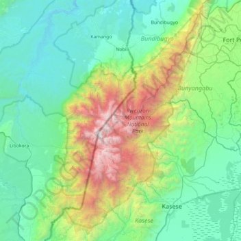
Nom : Carte topographique Rwenzori Mountains, altitude, relief.
Lieu : Rwenzori Mountains, Kasese, Western Region, Uganda (0.07049 29.74264 0.77055 30.18341)
Altitude moyenne : 1 570 m
Altitude minimum : 684 m
Altitude maximum : 5 017 m
Faire un don
Équipez-vous pour votre prochaine aventure :
En tant que Partenaire Amazon, ce site perçoit une commission sur les achats éligibles sans surcoût pour vous.
Autres cartes topographiques
Cliquez sur une carte pour visualiser sa topographie, son altitude et son relief.